You are here: Home > Network List > TJ - Tajikistan National Seismic Network Stations List
> Station GARM Garm, Tajikistan > Earthquake Result Viewer
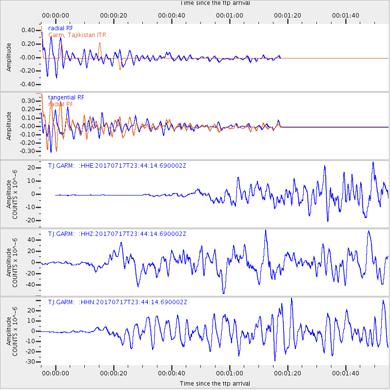
GARM Garm, Tajikistan - Earthquake Result Viewer
*The percent match for this event was below the threshold and hence no stack was calculated.
| Earthquake location: |
Komandorskiye Ostrova Region |
| Earthquake latitude/longitude: |
54.2/169.2 |
| Earthquake time(UTC): |
2017/07/17 (198) 23:34:21 GMT |
| Earthquake Depth: |
48 km |
| Earthquake Magnitude: |
7.4 Mi |
| Earthquake Catalog/Contributor: |
NEIC PDE/pt |
|
| Network: |
TJ Tajikistan National Seismic Network |
| Station: |
GARM Garm, Tajikistan |
| Lat/Lon: |
39.00 N/70.32 E |
| Elevation: |
1305 m |
|
| Distance: |
64.1 deg |
| Az: |
301.166 deg |
| Baz: |
40.18 deg |
| Ray Param: |
$rayparam |
*The percent match for this event was below the threshold and hence was not used in the summary stack. |
|
| Radial Match: |
86.585495 % |
| Radial Bump: |
400 |
| Transverse Match: |
86.5406 % |
| Transverse Bump: |
400 |
| SOD ConfigId: |
13570011 |
| Insert Time: |
2019-04-28 10:09:26.846 +0000 |
| GWidth: |
2.5 |
| Max Bumps: |
400 |
| Tol: |
0.001 |
|
Signal To Noise
| Channel | StoN | STA | LTA |
| TJ:GARM: :HHZ:20170717T23:44:14.690002Z | 12.042786 | 1.3823584E-6 | 1.1478726E-7 |
| TJ:GARM: :HHN:20170717T23:44:14.690002Z | 3.44835 | 4.5826044E-7 | 1.3289267E-7 |
| TJ:GARM: :HHE:20170717T23:44:14.690002Z | 4.948379 | 4.923138E-7 | 9.948991E-8 |
| Arrivals |
| Ps | |
| PpPs | |
| PsPs/PpSs | |


