You are here: Home > Network List > UW - Pacific Northwest Regional Seismic Network Stations List
> Station MRBL Marblemount, WA, USA > Earthquake Result Viewer
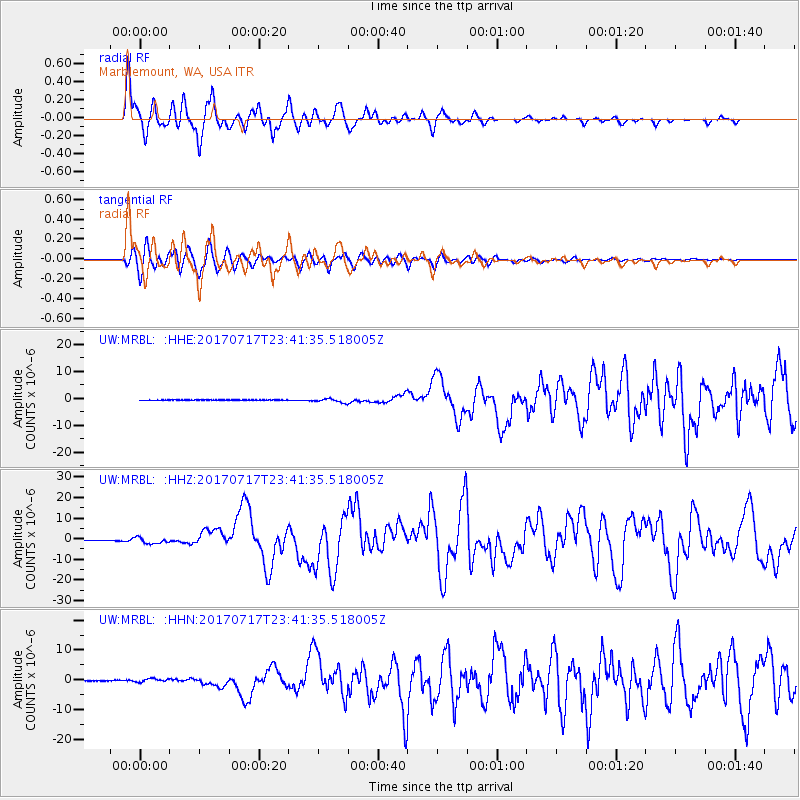
MRBL Marblemount, WA, USA - Earthquake Result Viewer
*The percent match for this event was below the threshold and hence no stack was calculated.
| Earthquake location: |
Komandorskiye Ostrova Region |
| Earthquake latitude/longitude: |
54.2/169.2 |
| Earthquake time(UTC): |
2017/07/17 (198) 23:34:21 GMT |
| Earthquake Depth: |
48 km |
| Earthquake Magnitude: |
7.4 Mi |
| Earthquake Catalog/Contributor: |
NEIC PDE/pt |
|
| Network: |
UW Pacific Northwest Regional Seismic Network |
| Station: |
MRBL Marblemount, WA, USA |
| Lat/Lon: |
48.52 N/121.48 W |
| Elevation: |
75 m |
|
| Distance: |
42.1 deg |
| Az: |
68.197 deg |
| Baz: |
304.868 deg |
| Ray Param: |
$rayparam |
*The percent match for this event was below the threshold and hence was not used in the summary stack. |
|
| Radial Match: |
93.62703 % |
| Radial Bump: |
400 |
| Transverse Match: |
91.808815 % |
| Transverse Bump: |
400 |
| SOD ConfigId: |
13570011 |
| Insert Time: |
2019-04-28 10:10:12.435 +0000 |
| GWidth: |
2.5 |
| Max Bumps: |
400 |
| Tol: |
0.001 |
|
Signal To Noise
| Channel | StoN | STA | LTA |
| UW:MRBL: :HHZ:20170717T23:41:35.518005Z | 8.8733225 | 1.5867863E-6 | 1.7882662E-7 |
| UW:MRBL: :HHN:20170717T23:41:35.518005Z | 5.134176 | 6.002689E-7 | 1.1691631E-7 |
| UW:MRBL: :HHE:20170717T23:41:35.518005Z | 8.973823 | 8.614988E-7 | 9.6001315E-8 |
| Arrivals |
| Ps | |
| PpPs | |
| PsPs/PpSs | |


