You are here: Home > Network List > TA - USArray Transportable Network (new EarthScope stations) Stations List
> Station L29A Maesberg Ranch, Thedford, NE, USA > Earthquake Result Viewer
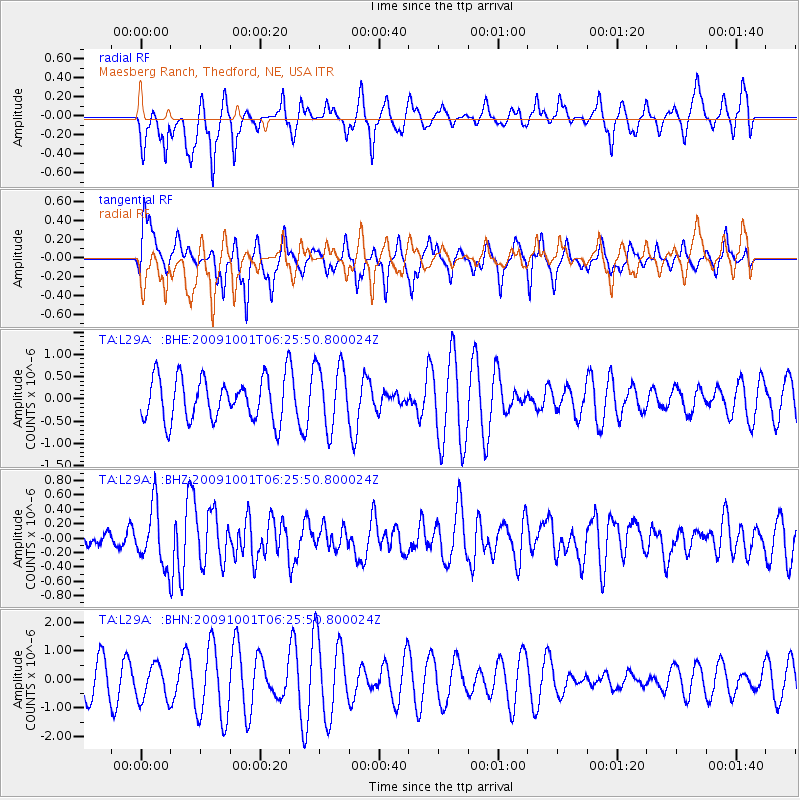
L29A Maesberg Ranch, Thedford, NE, USA - Earthquake Result Viewer
*The percent match for this event was below the threshold and hence no stack was calculated.
| Earthquake location: |
Tonga Islands |
| Earthquake latitude/longitude: |
-15.4/-173.3 |
| Earthquake time(UTC): |
2009/10/01 (274) 06:13:32 GMT |
| Earthquake Depth: |
10 km |
| Earthquake Magnitude: |
5.6 MB, 5.7 MS, 5.8 MW, 5.7 MW |
| Earthquake Catalog/Contributor: |
WHDF/NEIC |
|
| Network: |
TA USArray Transportable Network (new EarthScope stations) |
| Station: |
L29A Maesberg Ranch, Thedford, NE, USA |
| Lat/Lon: |
42.06 N/100.48 W |
| Elevation: |
901 m |
|
| Distance: |
87.9 deg |
| Az: |
45.374 deg |
| Baz: |
247.215 deg |
| Ray Param: |
$rayparam |
*The percent match for this event was below the threshold and hence was not used in the summary stack. |
|
| Radial Match: |
51.45278 % |
| Radial Bump: |
341 |
| Transverse Match: |
28.90354 % |
| Transverse Bump: |
268 |
| SOD ConfigId: |
2622 |
| Insert Time: |
2010-03-06 02:02:23.108 +0000 |
| GWidth: |
2.5 |
| Max Bumps: |
400 |
| Tol: |
0.001 |
|
Signal To Noise
| Channel | StoN | STA | LTA |
| TA:L29A: :BHZ:20091001T06:25:50.800024Z | 3.0721638 | 4.1079645E-7 | 1.3371567E-7 |
| TA:L29A: :BHN:20091001T06:25:50.800024Z | 0.90180814 | 6.2729606E-7 | 6.9559815E-7 |
| TA:L29A: :BHE:20091001T06:25:50.800024Z | 1.5013051 | 7.2642683E-7 | 4.838636E-7 |
| Arrivals |
| Ps | |
| PpPs | |
| PsPs/PpSs | |


