You are here: Home > Network List > TA - USArray Transportable Network (new EarthScope stations) Stations List
> Station L29A Maesberg Ranch, Thedford, NE, USA > Earthquake Result Viewer
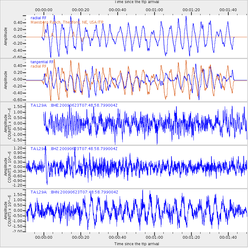
L29A Maesberg Ranch, Thedford, NE, USA - Earthquake Result Viewer
*The percent match for this event was below the threshold and hence no stack was calculated.
| Earthquake location: |
Near East Coast Of Honshu, Japan |
| Earthquake latitude/longitude: |
38.8/142.4 |
| Earthquake time(UTC): |
2009/06/23 (174) 07:37:17 GMT |
| Earthquake Depth: |
37 km |
| Earthquake Magnitude: |
5.7 MB, 5.0 MS, 5.6 MW, 5.6 MW |
| Earthquake Catalog/Contributor: |
WHDF/NEIC |
|
| Network: |
TA USArray Transportable Network (new EarthScope stations) |
| Station: |
L29A Maesberg Ranch, Thedford, NE, USA |
| Lat/Lon: |
42.06 N/100.48 W |
| Elevation: |
901 m |
|
| Distance: |
81.3 deg |
| Az: |
42.102 deg |
| Baz: |
315.327 deg |
| Ray Param: |
$rayparam |
*The percent match for this event was below the threshold and hence was not used in the summary stack. |
|
| Radial Match: |
63.426582 % |
| Radial Bump: |
400 |
| Transverse Match: |
50.42741 % |
| Transverse Bump: |
379 |
| SOD ConfigId: |
2648 |
| Insert Time: |
2010-03-06 02:02:38.671 +0000 |
| GWidth: |
2.5 |
| Max Bumps: |
400 |
| Tol: |
0.001 |
|
Signal To Noise
| Channel | StoN | STA | LTA |
| TA:L29A: :BHZ:20090623T07:48:58.799004Z | 3.0136185 | 5.3499537E-7 | 1.7752592E-7 |
| TA:L29A: :BHN:20090623T07:48:58.799004Z | 0.8900488 | 3.4257116E-7 | 3.848903E-7 |
| TA:L29A: :BHE:20090623T07:48:58.799004Z | 0.913961 | 4.955021E-7 | 5.421479E-7 |
| Arrivals |
| Ps | |
| PpPs | |
| PsPs/PpSs | |


