You are here: Home > Network List > TA - USArray Transportable Network (new EarthScope stations) Stations List
> Station Q29A Oakley, KS, USA > Earthquake Result Viewer
Q29A Oakley, KS, USA - Earthquake Result Viewer

| Earthquake location: |
Near S. Coast Of Honshu, Japan |
| Earthquake latitude/longitude: |
33.2/137.9 |
| Earthquake time(UTC): |
2009/08/09 (221) 10:55:55 GMT |
| Earthquake Depth: |
297 km |
| Earthquake Magnitude: |
6.5 MB, 7.1 MW, 7.1 MW |
| Earthquake Catalog/Contributor: |
WHDF/NEIC |
|
| Network: |
TA USArray Transportable Network (new EarthScope stations) |
| Station: |
Q29A Oakley, KS, USA |
| Lat/Lon: |
38.89 N/100.98 W |
| Elevation: |
895 m |
|
| Distance: |
89.9 deg |
| Az: |
41.942 deg |
| Baz: |
314.082 deg |
| Ray Param: |
0.041645784 |
| Estimated Moho Depth: |
43.0 km |
| Estimated Crust Vp/Vs: |
1.81 |
| Assumed Crust Vp: |
6.483 km/s |
| Estimated Crust Vs: |
3.577 km/s |
| Estimated Crust Poisson's Ratio: |
0.28 |
|
| Radial Match: |
94.67195 % |
| Radial Bump: |
400 |
| Transverse Match: |
84.6113 % |
| Transverse Bump: |
400 |
| SOD ConfigId: |
2622 |
| Insert Time: |
2010-03-06 02:02:43.301 +0000 |
| GWidth: |
2.5 |
| Max Bumps: |
400 |
| Tol: |
0.001 |
|
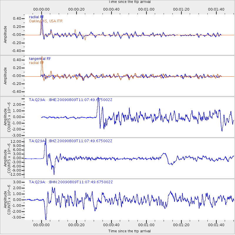
Signal To Noise
| Channel | StoN | STA | LTA |
| TA:Q29A: :BHZ:20090809T11:07:49.675002Z | 59.974777 | 5.094096E-6 | 8.4937305E-8 |
| TA:Q29A: :BHN:20090809T11:07:49.675002Z | 22.001675 | 1.3505822E-6 | 6.138543E-8 |
| TA:Q29A: :BHE:20090809T11:07:49.675002Z | 18.170387 | 1.3281931E-6 | 7.309657E-8 |
| Arrivals |
| Ps | 5.5 SECOND |
| PpPs | 18 SECOND |
| PsPs/PpSs | 24 SECOND |


