You are here: Home > Network List > CI - Caltech Regional Seismic Network Stations List
> Station SWS Sam W. Stewart, Westmorland, CA, USA > Earthquake Result Viewer
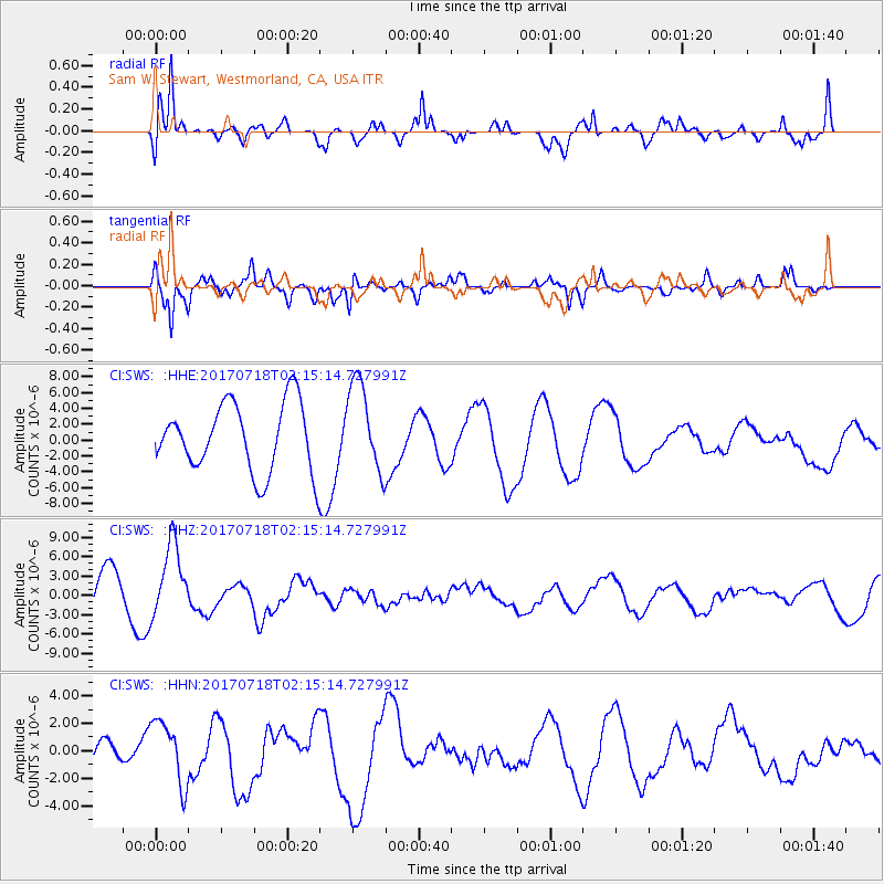
SWS Sam W. Stewart, Westmorland, CA, USA - Earthquake Result Viewer
*The percent match for this event was below the threshold and hence no stack was calculated.
| Earthquake location: |
Near Coast Of Peru |
| Earthquake latitude/longitude: |
-16.4/-73.6 |
| Earthquake time(UTC): |
2017/07/18 (199) 02:05:19 GMT |
| Earthquake Depth: |
44 km |
| Earthquake Magnitude: |
6.4 Mww |
| Earthquake Catalog/Contributor: |
NEIC PDE/us |
|
| Network: |
CI Caltech Regional Seismic Network |
| Station: |
SWS Sam W. Stewart, Westmorland, CA, USA |
| Lat/Lon: |
32.94 N/115.80 W |
| Elevation: |
140 m |
|
| Distance: |
63.5 deg |
| Az: |
320.873 deg |
| Baz: |
133.922 deg |
| Ray Param: |
$rayparam |
*The percent match for this event was below the threshold and hence was not used in the summary stack. |
|
| Radial Match: |
70.38414 % |
| Radial Bump: |
400 |
| Transverse Match: |
83.09866 % |
| Transverse Bump: |
327 |
| SOD ConfigId: |
13570011 |
| Insert Time: |
2019-04-28 10:13:03.631 +0000 |
| GWidth: |
2.5 |
| Max Bumps: |
400 |
| Tol: |
0.001 |
|
Signal To Noise
| Channel | StoN | STA | LTA |
| CI:SWS: :HHZ:20170718T02:15:14.727991Z | 1.746711 | 5.7429015E-6 | 3.2878372E-6 |
| CI:SWS: :HHN:20170718T02:15:14.727991Z | 1.3758779 | 2.3918467E-6 | 1.738415E-6 |
| CI:SWS: :HHE:20170718T02:15:14.727991Z | 1.3243355 | 5.7163206E-6 | 4.316369E-6 |
| Arrivals |
| Ps | |
| PpPs | |
| PsPs/PpSs | |


