You are here: Home > Network List > TA - USArray Transportable Network (new EarthScope stations) Stations List
> Station J25K Salcha River, AK, USA > Earthquake Result Viewer
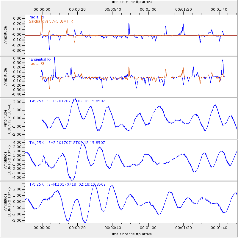
J25K Salcha River, AK, USA - Earthquake Result Viewer
*The percent match for this event was below the threshold and hence no stack was calculated.
| Earthquake location: |
Near Coast Of Peru |
| Earthquake latitude/longitude: |
-16.4/-73.6 |
| Earthquake time(UTC): |
2017/07/18 (199) 02:05:19 GMT |
| Earthquake Depth: |
44 km |
| Earthquake Magnitude: |
6.4 Mww |
| Earthquake Catalog/Contributor: |
NEIC PDE/us |
|
| Network: |
TA USArray Transportable Network (new EarthScope stations) |
| Station: |
J25K Salcha River, AK, USA |
| Lat/Lon: |
64.61 N/145.37 W |
| Elevation: |
949 m |
|
| Distance: |
97.1 deg |
| Az: |
335.631 deg |
| Baz: |
113.265 deg |
| Ray Param: |
$rayparam |
*The percent match for this event was below the threshold and hence was not used in the summary stack. |
|
| Radial Match: |
39.42853 % |
| Radial Bump: |
217 |
| Transverse Match: |
77.59541 % |
| Transverse Bump: |
368 |
| SOD ConfigId: |
13570011 |
| Insert Time: |
2019-04-28 10:17:32.814 +0000 |
| GWidth: |
2.5 |
| Max Bumps: |
400 |
| Tol: |
0.001 |
|
Signal To Noise
| Channel | StoN | STA | LTA |
| TA:J25K: :BHZ:20170718T02:18:15.850Z | 0.7041234 | 9.959152E-7 | 1.4144043E-6 |
| TA:J25K: :BHN:20170718T02:18:15.850Z | 0.32762498 | 4.1133882E-7 | 1.2555172E-6 |
| TA:J25K: :BHE:20170718T02:18:15.850Z | 0.97963804 | 1.0347098E-6 | 1.0562165E-6 |
| Arrivals |
| Ps | |
| PpPs | |
| PsPs/PpSs | |


