You are here: Home > Network List > TA - USArray Transportable Network (new EarthScope stations) Stations List
> Station P29A Atwood, KS, USA > Earthquake Result Viewer
P29A Atwood, KS, USA - Earthquake Result Viewer

| Earthquake location: |
Panama |
| Earthquake latitude/longitude: |
9.6/-79.0 |
| Earthquake time(UTC): |
2009/07/04 (185) 06:49:35 GMT |
| Earthquake Depth: |
38 km |
| Earthquake Magnitude: |
6.0 MB, 5.5 MS, 6.0 MW, 6.0 MW |
| Earthquake Catalog/Contributor: |
WHDF/NEIC |
|
| Network: |
TA USArray Transportable Network (new EarthScope stations) |
| Station: |
P29A Atwood, KS, USA |
| Lat/Lon: |
39.60 N/100.93 W |
| Elevation: |
929 m |
|
| Distance: |
35.7 deg |
| Az: |
330.344 deg |
| Baz: |
140.832 deg |
| Ray Param: |
0.07698329 |
| Estimated Moho Depth: |
52.25 km |
| Estimated Crust Vp/Vs: |
1.74 |
| Assumed Crust Vp: |
6.483 km/s |
| Estimated Crust Vs: |
3.72 km/s |
| Estimated Crust Poisson's Ratio: |
0.25 |
|
| Radial Match: |
87.07366 % |
| Radial Bump: |
345 |
| Transverse Match: |
59.73492 % |
| Transverse Bump: |
400 |
| SOD ConfigId: |
2648 |
| Insert Time: |
2010-03-06 02:03:41.125 +0000 |
| GWidth: |
2.5 |
| Max Bumps: |
400 |
| Tol: |
0.001 |
|
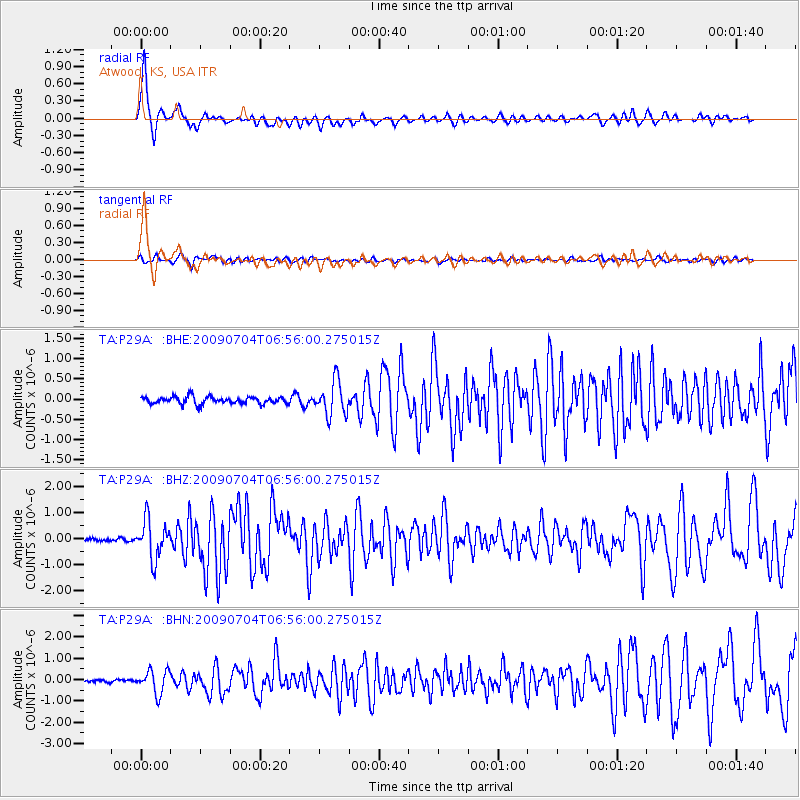
Signal To Noise
| Channel | StoN | STA | LTA |
| TA:P29A: :BHZ:20090704T06:56:00.275015Z | 13.372058 | 7.367423E-7 | 5.5095658E-8 |
| TA:P29A: :BHN:20090704T06:56:00.275015Z | 5.35414 | 5.3487474E-7 | 9.989929E-8 |
| TA:P29A: :BHE:20090704T06:56:00.275015Z | 4.819682 | 4.133274E-7 | 8.575823E-8 |
| Arrivals |
| Ps | 6.5 SECOND |
| PpPs | 20 SECOND |
| PsPs/PpSs | 27 SECOND |


