You are here: Home > Network List > AZ - ANZA Regional Network Stations List
> Station SMER AZ.SMER > Earthquake Result Viewer
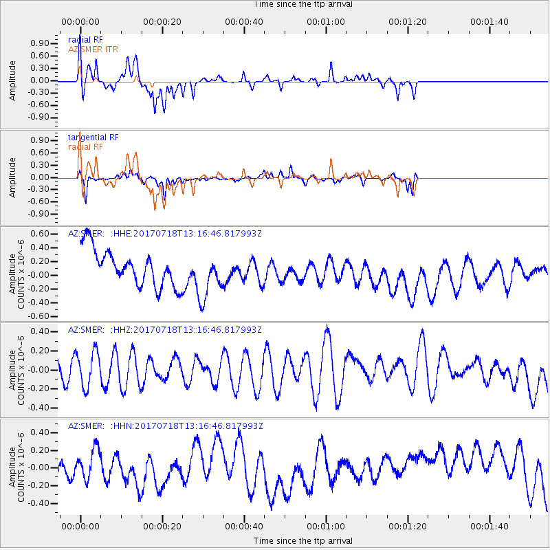
SMER AZ.SMER - Earthquake Result Viewer
*The percent match for this event was below the threshold and hence no stack was calculated.
| Earthquake location: |
Pacific-Antarctic Ridge |
| Earthquake latitude/longitude: |
-57.0/-141.4 |
| Earthquake time(UTC): |
2017/07/18 (199) 13:04:07 GMT |
| Earthquake Depth: |
10 km |
| Earthquake Magnitude: |
5.7 Mww |
| Earthquake Catalog/Contributor: |
NEIC PDE/us |
|
| Network: |
AZ ANZA Regional Network |
| Station: |
SMER AZ.SMER |
| Lat/Lon: |
33.46 N/117.17 W |
| Elevation: |
355 m |
|
| Distance: |
92.4 deg |
| Az: |
20.09 deg |
| Baz: |
193.004 deg |
| Ray Param: |
$rayparam |
*The percent match for this event was below the threshold and hence was not used in the summary stack. |
|
| Radial Match: |
78.95402 % |
| Radial Bump: |
365 |
| Transverse Match: |
63.607548 % |
| Transverse Bump: |
310 |
| SOD ConfigId: |
13570011 |
| Insert Time: |
2019-04-28 10:19:29.312 +0000 |
| GWidth: |
2.5 |
| Max Bumps: |
400 |
| Tol: |
0.001 |
|
Signal To Noise
| Channel | StoN | STA | LTA |
| AZ:SMER: :HHZ:20170718T13:16:46.817993Z | 1.144594 | 1.885287E-7 | 1.647123E-7 |
| AZ:SMER: :HHN:20170718T13:16:46.817993Z | 0.49733028 | 2.0417275E-7 | 4.1053755E-7 |
| AZ:SMER: :HHE:20170718T13:16:46.817993Z | 1.3395178 | 3.46728E-7 | 2.5884538E-7 |
| Arrivals |
| Ps | |
| PpPs | |
| PsPs/PpSs | |


