You are here: Home > Network List > TA - USArray Transportable Network (new EarthScope stations) Stations List
> Station P29A Atwood, KS, USA > Earthquake Result Viewer
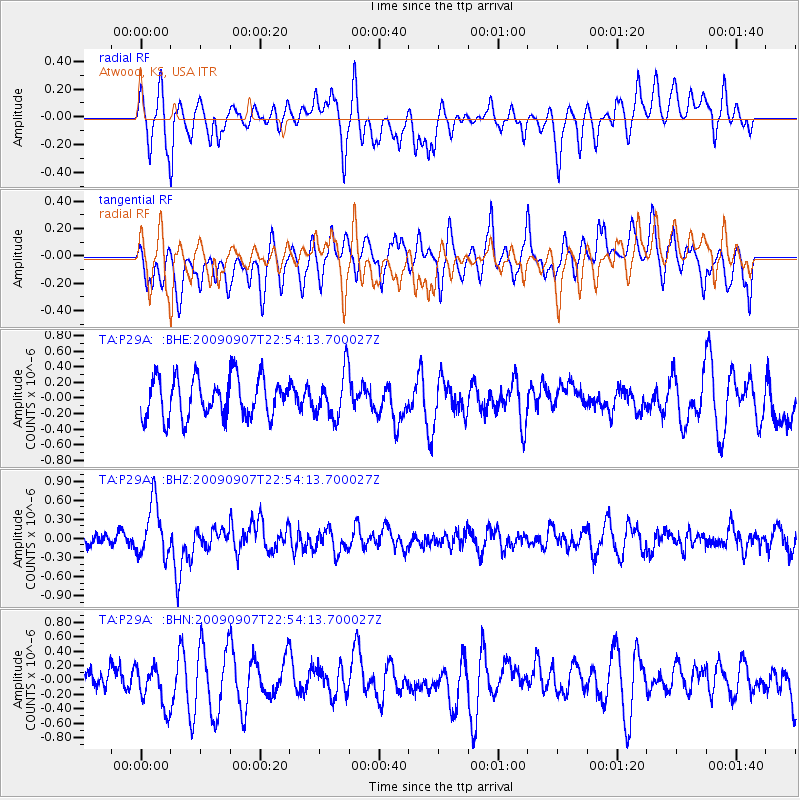
P29A Atwood, KS, USA - Earthquake Result Viewer
*The percent match for this event was below the threshold and hence no stack was calculated.
| Earthquake location: |
Northwestern Caucasus |
| Earthquake latitude/longitude: |
42.7/43.4 |
| Earthquake time(UTC): |
2009/09/07 (250) 22:41:37 GMT |
| Earthquake Depth: |
15 km |
| Earthquake Magnitude: |
5.7 MB, 5.8 MS, 6.0 MW, 5.9 MW |
| Earthquake Catalog/Contributor: |
WHDF/NEIC |
|
| Network: |
TA USArray Transportable Network (new EarthScope stations) |
| Station: |
P29A Atwood, KS, USA |
| Lat/Lon: |
39.60 N/100.93 W |
| Elevation: |
929 m |
|
| Distance: |
92.0 deg |
| Az: |
333.238 deg |
| Baz: |
25.463 deg |
| Ray Param: |
$rayparam |
*The percent match for this event was below the threshold and hence was not used in the summary stack. |
|
| Radial Match: |
57.167904 % |
| Radial Bump: |
400 |
| Transverse Match: |
58.229935 % |
| Transverse Bump: |
400 |
| SOD ConfigId: |
2622 |
| Insert Time: |
2010-03-06 02:03:52.254 +0000 |
| GWidth: |
2.5 |
| Max Bumps: |
400 |
| Tol: |
0.001 |
|
Signal To Noise
| Channel | StoN | STA | LTA |
| TA:P29A: :BHZ:20090907T22:54:13.700027Z | 4.573371 | 4.24143E-7 | 9.274188E-8 |
| TA:P29A: :BHN:20090907T22:54:13.700027Z | 1.0841918 | 2.8129284E-7 | 2.5944934E-7 |
| TA:P29A: :BHE:20090907T22:54:13.700027Z | 1.1614681 | 2.9419726E-7 | 2.5329774E-7 |
| Arrivals |
| Ps | |
| PpPs | |
| PsPs/PpSs | |


