You are here: Home > Network List > TA - USArray Transportable Network (new EarthScope stations) Stations List
> Station P29A Atwood, KS, USA > Earthquake Result Viewer
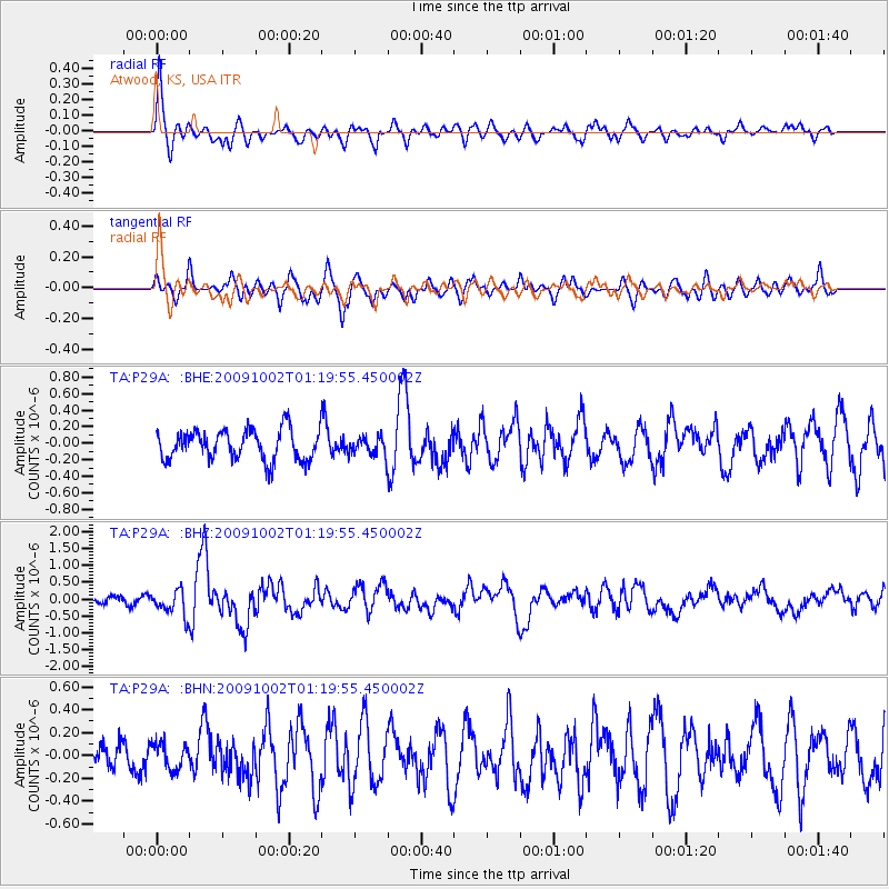
P29A Atwood, KS, USA - Earthquake Result Viewer
*The percent match for this event was below the threshold and hence no stack was calculated.
| Earthquake location: |
Tonga Islands |
| Earthquake latitude/longitude: |
-16.3/-173.5 |
| Earthquake time(UTC): |
2009/10/02 (275) 01:07:39 GMT |
| Earthquake Depth: |
8.0 km |
| Earthquake Magnitude: |
6.1 MB, 6.0 MS, 6.1 MW, 6.1 MW |
| Earthquake Catalog/Contributor: |
WHDF/NEIC |
|
| Network: |
TA USArray Transportable Network (new EarthScope stations) |
| Station: |
P29A Atwood, KS, USA |
| Lat/Lon: |
39.60 N/100.93 W |
| Elevation: |
929 m |
|
| Distance: |
87.4 deg |
| Az: |
47.539 deg |
| Baz: |
246.468 deg |
| Ray Param: |
$rayparam |
*The percent match for this event was below the threshold and hence was not used in the summary stack. |
|
| Radial Match: |
72.53071 % |
| Radial Bump: |
400 |
| Transverse Match: |
57.82781 % |
| Transverse Bump: |
400 |
| SOD ConfigId: |
2622 |
| Insert Time: |
2010-03-06 02:03:59.149 +0000 |
| GWidth: |
2.5 |
| Max Bumps: |
400 |
| Tol: |
0.001 |
|
Signal To Noise
| Channel | StoN | STA | LTA |
| TA:P29A: :BHZ:20091002T01:19:55.450002Z | 3.2445014 | 3.7568284E-7 | 1.1579063E-7 |
| TA:P29A: :BHN:20091002T01:19:55.450002Z | 0.6508331 | 1.1404155E-7 | 1.7522397E-7 |
| TA:P29A: :BHE:20091002T01:19:55.450002Z | 0.6251797 | 1.1394437E-7 | 1.8225857E-7 |
| Arrivals |
| Ps | |
| PpPs | |
| PsPs/PpSs | |


