You are here: Home > Network List > TA - USArray Transportable Network (new EarthScope stations) Stations List
> Station M28A Bar X Bar Ranch, Keystone, NE, USA > Earthquake Result Viewer
M28A Bar X Bar Ranch, Keystone, NE, USA - Earthquake Result Viewer
| Earthquake location: |
Southeast Of Honshu, Japan |
| Earthquake latitude/longitude: |
32.8/140.4 |
| Earthquake time(UTC): |
2009/08/12 (224) 22:48:51 GMT |
| Earthquake Depth: |
53 km |
| Earthquake Magnitude: |
6.2 MB, 6.6 MW, 6.6 MW |
| Earthquake Catalog/Contributor: |
WHDF/NEIC |
|
| Network: |
TA USArray Transportable Network (new EarthScope stations) |
| Station: |
M28A Bar X Bar Ranch, Keystone, NE, USA |
| Lat/Lon: |
41.40 N/101.37 W |
| Elevation: |
1071 m |
|
| Distance: |
86.8 deg |
| Az: |
41.596 deg |
| Baz: |
312.013 deg |
| Ray Param: |
0.04368955 |
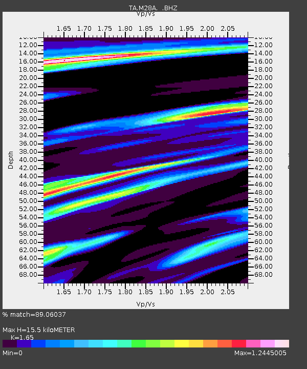
| Estimated Moho Depth: |
15.5 km |
| Estimated Crust Vp/Vs: |
1.65 |
| Assumed Crust Vp: |
6.483 km/s |
| Estimated Crust Vs: |
3.929 km/s |
| Estimated Crust Poisson's Ratio: |
0.21 |
|
| Radial Match: |
89.06037 % |
| Radial Bump: |
400 |
| Transverse Match: |
82.375 % |
| Transverse Bump: |
400 |
| SOD ConfigId: |
2622 |
| Insert Time: |
2010-03-06 02:04:19.103 +0000 |
| GWidth: |
2.5 |
| Max Bumps: |
400 |
| Tol: |
0.001 |
|

Signal To Noise
| Channel | StoN | STA | LTA |
| TA:M28A: :BHZ:20090812T23:00:58.875017Z | 22.92413 | 2.6101166E-6 | 1.13858924E-7 |
| TA:M28A: :BHN:20090812T23:00:58.875017Z | 3.3128726 | 7.846055E-7 | 2.3683539E-7 |
| TA:M28A: :BHE:20090812T23:00:58.875017Z | 4.579041 | 1.0929386E-6 | 2.386829E-7 |
| Arrivals |
| Ps | 1.6 SECOND |
| PpPs | 6.2 SECOND |
| PsPs/PpSs | 7.8 SECOND |


