You are here: Home > Network List > TA - USArray Transportable Network (new EarthScope stations) Stations List
> Station M28A Bar X Bar Ranch, Keystone, NE, USA > Earthquake Result Viewer
M28A Bar X Bar Ranch, Keystone, NE, USA - Earthquake Result Viewer
| Earthquake location: |
Northern Mid-Atlantic Ridge |
| Earthquake latitude/longitude: |
23.9/-46.1 |
| Earthquake time(UTC): |
2009/06/06 (157) 20:33:28 GMT |
| Earthquake Depth: |
14 km |
| Earthquake Magnitude: |
6.0 MB, 5.7 MS, 6.0 MW, 6.0 MW |
| Earthquake Catalog/Contributor: |
WHDF/NEIC |
|
| Network: |
TA USArray Transportable Network (new EarthScope stations) |
| Station: |
M28A Bar X Bar Ranch, Keystone, NE, USA |
| Lat/Lon: |
41.40 N/101.37 W |
| Elevation: |
1071 m |
|
| Distance: |
48.9 deg |
| Az: |
304.857 deg |
| Baz: |
93.115 deg |
| Ray Param: |
0.06904706 |
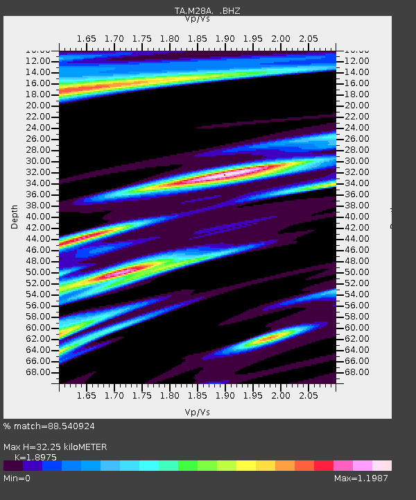
| Estimated Moho Depth: |
32.25 km |
| Estimated Crust Vp/Vs: |
1.90 |
| Assumed Crust Vp: |
6.483 km/s |
| Estimated Crust Vs: |
3.416 km/s |
| Estimated Crust Poisson's Ratio: |
0.31 |
|
| Radial Match: |
88.540924 % |
| Radial Bump: |
384 |
| Transverse Match: |
80.20951 % |
| Transverse Bump: |
400 |
| SOD ConfigId: |
2648 |
| Insert Time: |
2010-03-06 02:04:32.826 +0000 |
| GWidth: |
2.5 |
| Max Bumps: |
400 |
| Tol: |
0.001 |
|

Signal To Noise
| Channel | StoN | STA | LTA |
| TA:M28A: :BHZ:20090606T20:41:43.150007Z | 9.4130945 | 1.1594574E-6 | 1.2317494E-7 |
| TA:M28A: :BHN:20090606T20:41:43.150007Z | 1.4110327 | 3.5047685E-7 | 2.4838323E-7 |
| TA:M28A: :BHE:20090606T20:41:43.150007Z | 1.2444924 | 4.6475225E-7 | 3.7344722E-7 |
| Arrivals |
| Ps | 4.7 SECOND |
| PpPs | 14 SECOND |
| PsPs/PpSs | 18 SECOND |


