You are here: Home > Network List > G - GEOSCOPE Stations List
> Station INU Inuyama, Japan > Earthquake Result Viewer
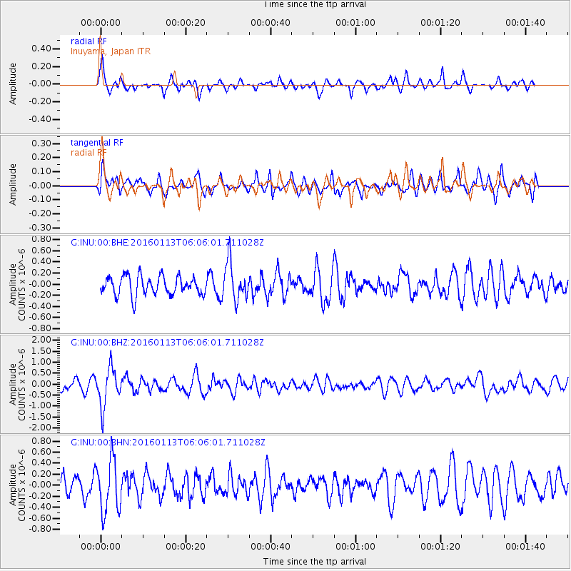
INU Inuyama, Japan - Earthquake Result Viewer
*The percent match for this event was below the threshold and hence no stack was calculated.
| Earthquake location: |
Tonga Islands |
| Earthquake latitude/longitude: |
-15.2/-174.9 |
| Earthquake time(UTC): |
2016/01/13 (013) 05:55:59 GMT |
| Earthquake Depth: |
233 km |
| Earthquake Magnitude: |
5.8 MB |
| Earthquake Catalog/Contributor: |
NEIC PDE/NEIC COMCAT |
|
| Network: |
G GEOSCOPE |
| Station: |
INU Inuyama, Japan |
| Lat/Lon: |
35.35 N/137.03 E |
| Elevation: |
132 m |
|
| Distance: |
67.8 deg |
| Az: |
318.95 deg |
| Baz: |
129.138 deg |
| Ray Param: |
$rayparam |
*The percent match for this event was below the threshold and hence was not used in the summary stack. |
|
| Radial Match: |
63.563942 % |
| Radial Bump: |
400 |
| Transverse Match: |
52.275616 % |
| Transverse Bump: |
400 |
| SOD ConfigId: |
1399611 |
| Insert Time: |
2016-01-27 06:06:25.807 +0000 |
| GWidth: |
2.5 |
| Max Bumps: |
400 |
| Tol: |
0.001 |
|
Signal To Noise
| Channel | StoN | STA | LTA |
| G:INU:00:BHZ:20160113T06:06:01.711028Z | 3.346759 | 9.086157E-7 | 2.7149122E-7 |
| G:INU:00:BHN:20160113T06:06:01.711028Z | 2.5391214 | 4.7967933E-7 | 1.889155E-7 |
| G:INU:00:BHE:20160113T06:06:01.711028Z | 2.0682862 | 3.4909846E-7 | 1.6878633E-7 |
| Arrivals |
| Ps | |
| PpPs | |
| PsPs/PpSs | |


