You are here: Home > Network List > TA - USArray Transportable Network (new EarthScope stations) Stations List
> Station M28A Bar X Bar Ranch, Keystone, NE, USA > Earthquake Result Viewer
M28A Bar X Bar Ranch, Keystone, NE, USA - Earthquake Result Viewer
| Earthquake location: |
Southern Peru |
| Earthquake latitude/longitude: |
-15.0/-70.4 |
| Earthquake time(UTC): |
2009/07/12 (193) 06:12:47 GMT |
| Earthquake Depth: |
199 km |
| Earthquake Magnitude: |
5.7 MB, 6.1 MW, 6.1 MW |
| Earthquake Catalog/Contributor: |
WHDF/NEIC |
|
| Network: |
TA USArray Transportable Network (new EarthScope stations) |
| Station: |
M28A Bar X Bar Ranch, Keystone, NE, USA |
| Lat/Lon: |
41.40 N/101.37 W |
| Elevation: |
1071 m |
|
| Distance: |
63.0 deg |
| Az: |
334.285 deg |
| Baz: |
146.138 deg |
| Ray Param: |
0.059240337 |
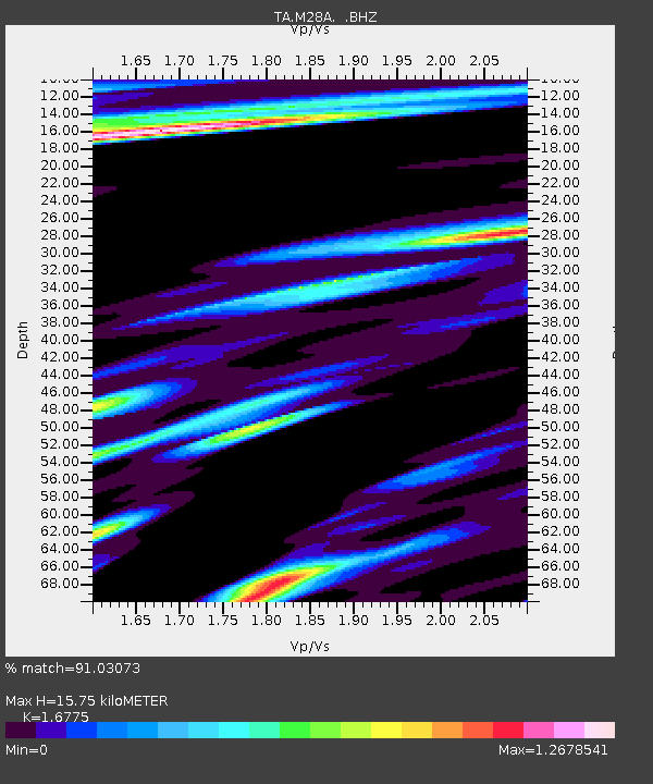
| Estimated Moho Depth: |
15.75 km |
| Estimated Crust Vp/Vs: |
1.68 |
| Assumed Crust Vp: |
6.483 km/s |
| Estimated Crust Vs: |
3.864 km/s |
| Estimated Crust Poisson's Ratio: |
0.22 |
|
| Radial Match: |
91.03073 % |
| Radial Bump: |
348 |
| Transverse Match: |
83.66165 % |
| Transverse Bump: |
400 |
| SOD ConfigId: |
2648 |
| Insert Time: |
2010-03-06 02:04:38.561 +0000 |
| GWidth: |
2.5 |
| Max Bumps: |
400 |
| Tol: |
0.001 |
|

Signal To Noise
| Channel | StoN | STA | LTA |
| TA:M28A: :BHZ:20090712T06:22:22.249006Z | 20.977789 | 2.271075E-6 | 1.0826093E-7 |
| TA:M28A: :BHN:20090712T06:22:22.249006Z | 1.6184531 | 4.1983697E-7 | 2.5940633E-7 |
| TA:M28A: :BHE:20090712T06:22:22.249006Z | 0.8790158 | 1.7231636E-7 | 1.960333E-7 |
| Arrivals |
| Ps | 1.7 SECOND |
| PpPs | 6.2 SECOND |
| PsPs/PpSs | 7.9 SECOND |


