You are here: Home > Network List > TA - USArray Transportable Network (new EarthScope stations) Stations List
> Station M28A Bar X Bar Ranch, Keystone, NE, USA > Earthquake Result Viewer
M28A Bar X Bar Ranch, Keystone, NE, USA - Earthquake Result Viewer
*The percent match for this event was below the threshold and hence no stack was calculated.
| Earthquake location: |
Rat Islands, Aleutian Islands |
| Earthquake latitude/longitude: |
52.2/178.1 |
| Earthquake time(UTC): |
2009/10/07 (280) 05:38:37 GMT |
| Earthquake Depth: |
138 km |
| Earthquake Magnitude: |
5.6 MB, 5.6 MW, 5.6 MW |
| Earthquake Catalog/Contributor: |
WHDF/NEIC |
|
| Network: |
TA USArray Transportable Network (new EarthScope stations) |
| Station: |
M28A Bar X Bar Ranch, Keystone, NE, USA |
| Lat/Lon: |
41.40 N/101.37 W |
| Elevation: |
1071 m |
|
| Distance: |
53.5 deg |
| Az: |
67.41 deg |
| Baz: |
310.885 deg |
| Ray Param: |
$rayparam |
*The percent match for this event was below the threshold and hence was not used in the summary stack. |
|
| Radial Match: |
53.55801 % |
| Radial Bump: |
400 |
| Transverse Match: |
62.414738 % |
| Transverse Bump: |
400 |
| SOD ConfigId: |
2622 |
| Insert Time: |
2010-03-06 02:04:53.401 +0000 |
| GWidth: |
2.5 |
| Max Bumps: |
400 |
| Tol: |
0.001 |
|
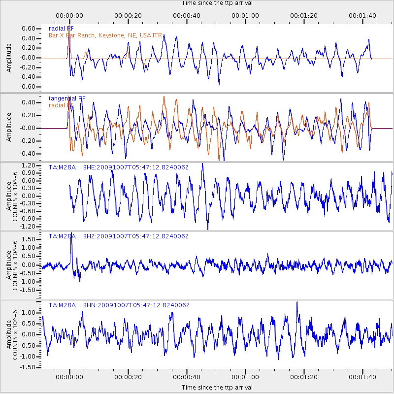
Signal To Noise
| Channel | StoN | STA | LTA |
| TA:M28A: :BHZ:20091007T05:47:12.824006Z | 3.4495091 | 6.0242667E-7 | 1.7464127E-7 |
| TA:M28A: :BHN:20091007T05:47:12.824006Z | 1.025576 | 4.0913503E-7 | 3.9893195E-7 |
| TA:M28A: :BHE:20091007T05:47:12.824006Z | 0.89209735 | 4.4834974E-7 | 5.025794E-7 |
| Arrivals |
| Ps | |
| PpPs | |
| PsPs/PpSs | |


