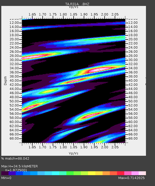
R31A Burdett, KS, USA - Earthquake Result Viewer
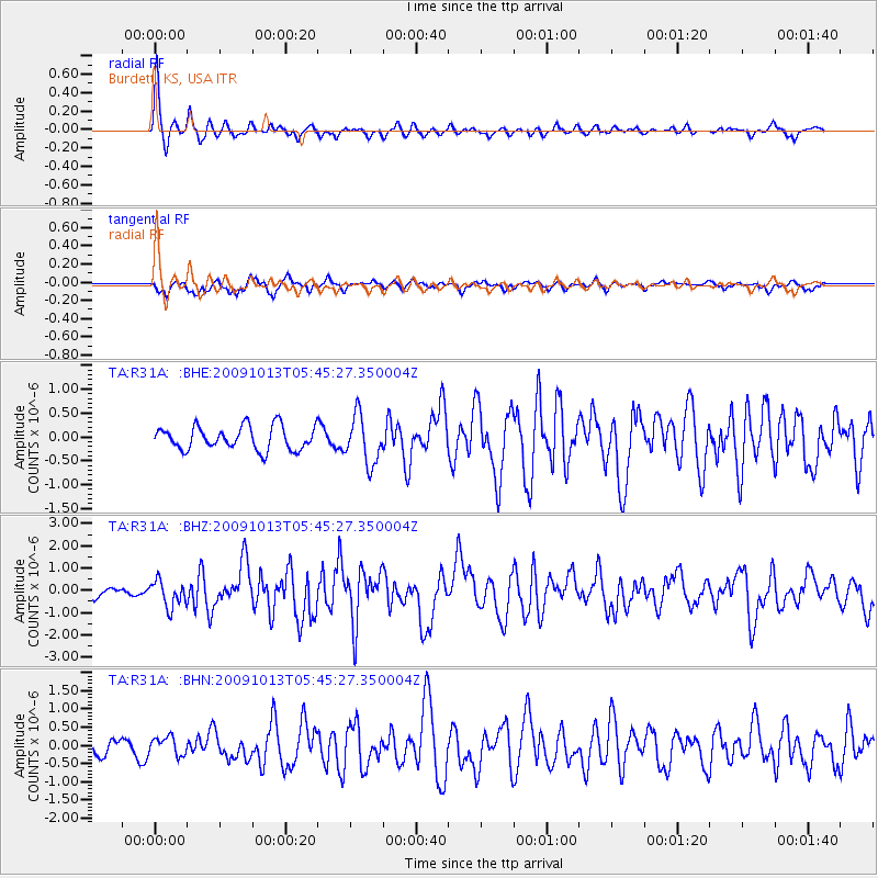
Earthquake location: Fox Islands, Aleutian Islands
Earthquake latitude/longitude: 52.8/-167.0
Earthquake time(UTC): 2009/10/13 (286) 05:37:23 GMT
Earthquake Depth: 24 km
Earthquake Magnitude: 6.0 MB, 6.1 MS, 6.5 MW, 6.5 MW
Earthquake Catalog/Contributor: WHDF/NEIC
Network: TA USArray Transportable Network (new EarthScope stations)
Station: R31A Burdett, KS, USA
Lat/Lon: 38.29 N/99.53 W
Elevation: 667 m
Distance: 47.7 deg
Az: 79.431 deg
Baz: 310.598 deg
Ray Param: 0.069798484
Estimated Moho Depth: 34.5 km
Estimated Crust Vp/Vs: 1.97
Assumed Crust Vp: 6.483 km/s
Estimated Crust Vs: 3.286 km/s
Estimated Crust Poisson's Ratio: 0.33
Radial Match: 88.042 %
Radial Bump: 301
Transverse Match: 65.8892 %
Transverse Bump: 400
SOD ConfigId: 2622
Insert Time: 2010-03-06 02:05:22.106 +0000
GWidth: 2.5
Max Bumps: 400
Tol: 0.001

Signal To Noise

ChannelStoNSTALTA
TA:R31A: :BHZ:20091013T05:45:27.350004Z1.91572075.8483926E-73.052842E-7
TA:R31A: :BHN:20091013T05:45:27.350004Z1.15686762.44958E-72.1174246E-7
TA:R31A: :BHE:20091013T05:45:27.350004Z2.08101465.027693E-72.4159814E-7
Arrivals
Ps5.5 SECOND
PpPs15 SECOND
PsPs/PpSs20 SECOND