You are here: Home > Network List > TA - USArray Transportable Network (new EarthScope stations) Stations List
> Station R31A Burdett, KS, USA > Earthquake Result Viewer
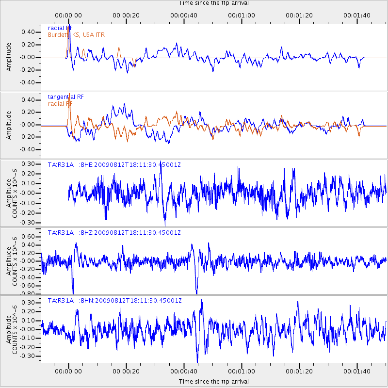
R31A Burdett, KS, USA - Earthquake Result Viewer
*The percent match for this event was below the threshold and hence no stack was calculated.
| Earthquake location: |
Catamarca Province, Argentina |
| Earthquake latitude/longitude: |
-27.9/-66.7 |
| Earthquake time(UTC): |
2009/08/12 (224) 18:00:52 GMT |
| Earthquake Depth: |
174 km |
| Earthquake Magnitude: |
5.5 MW, 5.3 MB, 5.5 MW |
| Earthquake Catalog/Contributor: |
WHDF/NEIC |
|
| Network: |
TA USArray Transportable Network (new EarthScope stations) |
| Station: |
R31A Burdett, KS, USA |
| Lat/Lon: |
38.29 N/99.53 W |
| Elevation: |
667 m |
|
| Distance: |
72.7 deg |
| Az: |
333.434 deg |
| Baz: |
149.799 deg |
| Ray Param: |
$rayparam |
*The percent match for this event was below the threshold and hence was not used in the summary stack. |
|
| Radial Match: |
59.839172 % |
| Radial Bump: |
400 |
| Transverse Match: |
64.04636 % |
| Transverse Bump: |
400 |
| SOD ConfigId: |
2622 |
| Insert Time: |
2010-03-06 02:05:33.936 +0000 |
| GWidth: |
2.5 |
| Max Bumps: |
400 |
| Tol: |
0.001 |
|
Signal To Noise
| Channel | StoN | STA | LTA |
| TA:R31A: :BHZ:20090812T18:11:30.45001Z | 1.7904195 | 2.743262E-7 | 1.5321896E-7 |
| TA:R31A: :BHN:20090812T18:11:30.45001Z | 1.8929826 | 1.1757621E-7 | 6.211162E-8 |
| TA:R31A: :BHE:20090812T18:11:30.45001Z | 1.9994429 | 1.5067998E-7 | 7.536098E-8 |
| Arrivals |
| Ps | |
| PpPs | |
| PsPs/PpSs | |


