You are here: Home > Network List > TA - USArray Transportable Network (new EarthScope stations) Stations List
> Station G21K Allakaket, AK, USA > Earthquake Result Viewer
G21K Allakaket, AK, USA - Earthquake Result Viewer
| Earthquake location: |
Near East Coast Of Honshu, Japan |
| Earthquake latitude/longitude: |
37.4/141.6 |
| Earthquake time(UTC): |
2017/07/20 (201) 00:11:25 GMT |
| Earthquake Depth: |
35 km |
| Earthquake Magnitude: |
5.8 Mww |
| Earthquake Catalog/Contributor: |
NEIC PDE/us |
|
| Network: |
TA USArray Transportable Network (new EarthScope stations) |
| Station: |
G21K Allakaket, AK, USA |
| Lat/Lon: |
66.52 N/153.51 W |
| Elevation: |
446 m |
|
| Distance: |
46.4 deg |
| Az: |
30.082 deg |
| Baz: |
264.7 deg |
| Ray Param: |
0.07060685 |
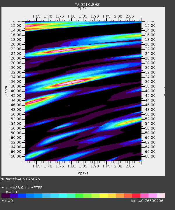
| Estimated Moho Depth: |
36.0 km |
| Estimated Crust Vp/Vs: |
1.80 |
| Assumed Crust Vp: |
6.455 km/s |
| Estimated Crust Vs: |
3.586 km/s |
| Estimated Crust Poisson's Ratio: |
0.28 |
|
| Radial Match: |
86.045845 % |
| Radial Bump: |
400 |
| Transverse Match: |
74.8774 % |
| Transverse Bump: |
400 |
| SOD ConfigId: |
13570011 |
| Insert Time: |
2019-04-28 10:33:15.296 +0000 |
| GWidth: |
2.5 |
| Max Bumps: |
400 |
| Tol: |
0.001 |
|
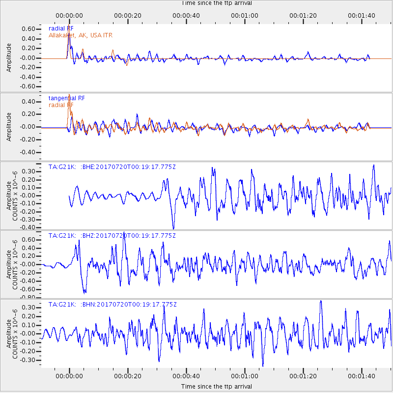
Signal To Noise
| Channel | StoN | STA | LTA |
| TA:G21K: :BHZ:20170720T00:19:17.775Z | 6.321015 | 2.889073E-7 | 4.5705843E-8 |
| TA:G21K: :BHN:20170720T00:19:17.775Z | 1.3459841 | 6.069764E-8 | 4.5095355E-8 |
| TA:G21K: :BHE:20170720T00:19:17.775Z | 2.2143452 | 1.1026478E-7 | 4.9795656E-8 |
| Arrivals |
| Ps | 4.7 SECOND |
| PpPs | 15 SECOND |
| PsPs/PpSs | 19 SECOND |


