You are here: Home > Network List > TA - USArray Transportable Network (new EarthScope stations) Stations List
> Station H23K Yukon River, AK, USA > Earthquake Result Viewer
H23K Yukon River, AK, USA - Earthquake Result Viewer
| Earthquake location: |
Near East Coast Of Honshu, Japan |
| Earthquake latitude/longitude: |
37.4/141.6 |
| Earthquake time(UTC): |
2017/07/20 (201) 00:11:25 GMT |
| Earthquake Depth: |
35 km |
| Earthquake Magnitude: |
5.8 Mww |
| Earthquake Catalog/Contributor: |
NEIC PDE/us |
|
| Network: |
TA USArray Transportable Network (new EarthScope stations) |
| Station: |
H23K Yukon River, AK, USA |
| Lat/Lon: |
65.83 N/149.54 W |
| Elevation: |
617 m |
|
| Distance: |
48.0 deg |
| Az: |
31.145 deg |
| Baz: |
269.044 deg |
| Ray Param: |
0.069595106 |
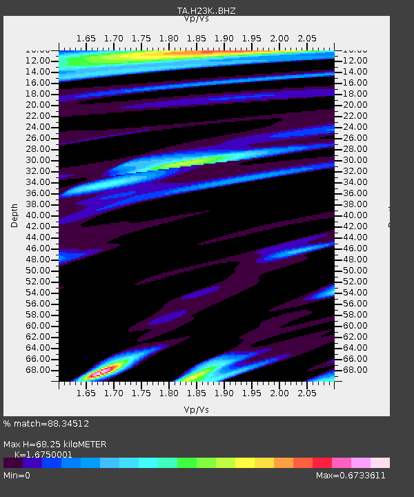
| Estimated Moho Depth: |
68.25 km |
| Estimated Crust Vp/Vs: |
1.68 |
| Assumed Crust Vp: |
6.566 km/s |
| Estimated Crust Vs: |
3.92 km/s |
| Estimated Crust Poisson's Ratio: |
0.22 |
|
| Radial Match: |
88.34512 % |
| Radial Bump: |
400 |
| Transverse Match: |
75.70115 % |
| Transverse Bump: |
400 |
| SOD ConfigId: |
13570011 |
| Insert Time: |
2019-04-28 10:33:27.241 +0000 |
| GWidth: |
2.5 |
| Max Bumps: |
400 |
| Tol: |
0.001 |
|

Signal To Noise
| Channel | StoN | STA | LTA |
| TA:H23K: :BHZ:20170720T00:19:29.975012Z | 3.8225996 | 2.9571254E-7 | 7.735902E-8 |
| TA:H23K: :BHN:20170720T00:19:29.975012Z | 1.2998351 | 5.4745186E-8 | 4.2117023E-8 |
| TA:H23K: :BHE:20170720T00:19:29.975012Z | 2.5190392 | 1.3265887E-7 | 5.2662486E-8 |
| Arrivals |
| Ps | 7.5 SECOND |
| PpPs | 26 SECOND |
| PsPs/PpSs | 33 SECOND |


