You are here: Home > Network List > TA - USArray Transportable Network (new EarthScope stations) Stations List
> Station R31A Burdett, KS, USA > Earthquake Result Viewer
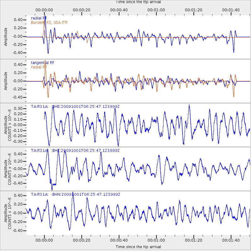
R31A Burdett, KS, USA - Earthquake Result Viewer
*The percent match for this event was below the threshold and hence no stack was calculated.
| Earthquake location: |
Tonga Islands |
| Earthquake latitude/longitude: |
-15.4/-173.3 |
| Earthquake time(UTC): |
2009/10/01 (274) 06:13:32 GMT |
| Earthquake Depth: |
10 km |
| Earthquake Magnitude: |
5.6 MB, 5.7 MS, 5.8 MW, 5.7 MW |
| Earthquake Catalog/Contributor: |
WHDF/NEIC |
|
| Network: |
TA USArray Transportable Network (new EarthScope stations) |
| Station: |
R31A Burdett, KS, USA |
| Lat/Lon: |
38.29 N/99.53 W |
| Elevation: |
667 m |
|
| Distance: |
87.1 deg |
| Az: |
49.141 deg |
| Baz: |
247.99 deg |
| Ray Param: |
$rayparam |
*The percent match for this event was below the threshold and hence was not used in the summary stack. |
|
| Radial Match: |
69.968506 % |
| Radial Bump: |
400 |
| Transverse Match: |
56.25478 % |
| Transverse Bump: |
400 |
| SOD ConfigId: |
2622 |
| Insert Time: |
2010-03-06 02:05:47.969 +0000 |
| GWidth: |
2.5 |
| Max Bumps: |
400 |
| Tol: |
0.001 |
|
Signal To Noise
| Channel | StoN | STA | LTA |
| TA:R31A: :BHZ:20091001T06:25:47.123999Z | 2.5851073 | 3.2681166E-7 | 1.2642093E-7 |
| TA:R31A: :BHN:20091001T06:25:47.123999Z | 1.07106 | 1.8470155E-7 | 1.7244743E-7 |
| TA:R31A: :BHE:20091001T06:25:47.123999Z | 0.84275365 | 1.3728805E-7 | 1.6290413E-7 |
| Arrivals |
| Ps | |
| PpPs | |
| PsPs/PpSs | |


