You are here: Home > Network List > TA - USArray Transportable Network (new EarthScope stations) Stations List
> Station J26L Joseph Creek, AK, USA > Earthquake Result Viewer
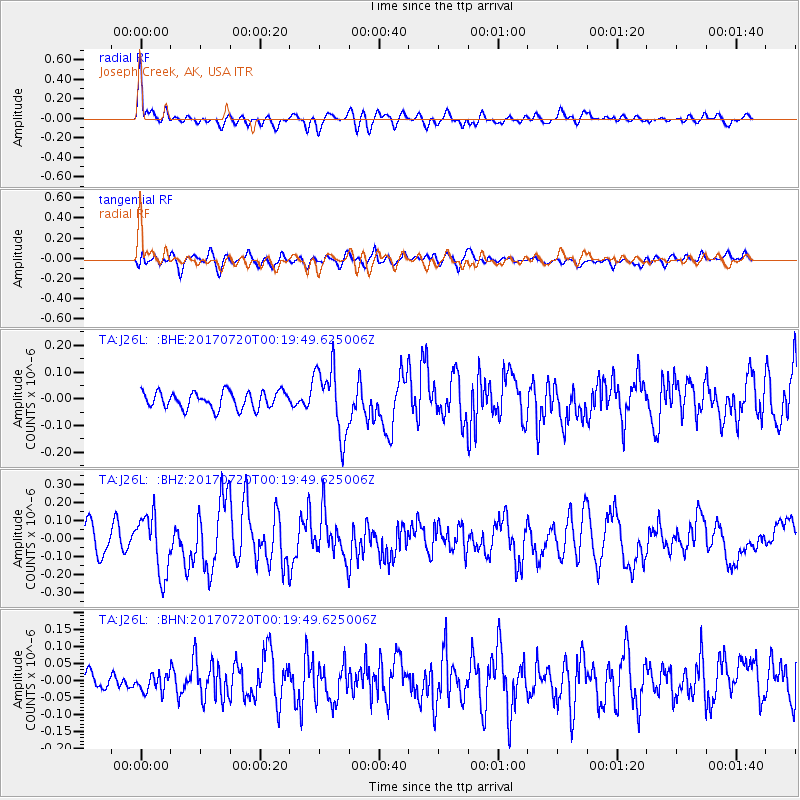
J26L Joseph Creek, AK, USA - Earthquake Result Viewer
*The percent match for this event was below the threshold and hence no stack was calculated.
| Earthquake location: |
Near East Coast Of Honshu, Japan |
| Earthquake latitude/longitude: |
37.4/141.6 |
| Earthquake time(UTC): |
2017/07/20 (201) 00:11:25 GMT |
| Earthquake Depth: |
35 km |
| Earthquake Magnitude: |
5.8 Mww |
| Earthquake Catalog/Contributor: |
NEIC PDE/us |
|
| Network: |
TA USArray Transportable Network (new EarthScope stations) |
| Station: |
J26L Joseph Creek, AK, USA |
| Lat/Lon: |
64.50 N/143.56 W |
| Elevation: |
1144 m |
|
| Distance: |
50.5 deg |
| Az: |
32.764 deg |
| Baz: |
275.522 deg |
| Ray Param: |
$rayparam |
*The percent match for this event was below the threshold and hence was not used in the summary stack. |
|
| Radial Match: |
74.795715 % |
| Radial Bump: |
400 |
| Transverse Match: |
59.473328 % |
| Transverse Bump: |
400 |
| SOD ConfigId: |
13570011 |
| Insert Time: |
2019-04-28 10:33:42.863 +0000 |
| GWidth: |
2.5 |
| Max Bumps: |
400 |
| Tol: |
0.001 |
|
Signal To Noise
| Channel | StoN | STA | LTA |
| TA:J26L: :BHZ:20170720T00:19:49.625006Z | 2.9037764 | 1.6334751E-7 | 5.625347E-8 |
| TA:J26L: :BHN:20170720T00:19:49.625006Z | 0.59193885 | 2.6590083E-8 | 4.492032E-8 |
| TA:J26L: :BHE:20170720T00:19:49.625006Z | 4.023552 | 1.2520965E-7 | 3.1119182E-8 |
| Arrivals |
| Ps | |
| PpPs | |
| PsPs/PpSs | |


