You are here: Home > Network List > TA - USArray Transportable Network (new EarthScope stations) Stations List
> Station M26K Nabesna, AK, USA > Earthquake Result Viewer
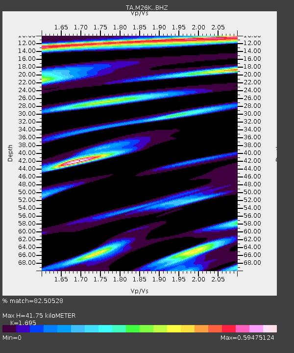
M26K Nabesna, AK, USA - Earthquake Result Viewer
| Earthquake location: |
Near East Coast Of Honshu, Japan |
| Earthquake latitude/longitude: |
37.4/141.6 |
| Earthquake time(UTC): |
2017/07/20 (201) 00:11:25 GMT |
| Earthquake Depth: |
35 km |
| Earthquake Magnitude: |
5.8 Mww |
| Earthquake Catalog/Contributor: |
NEIC PDE/us |
|
| Network: |
TA USArray Transportable Network (new EarthScope stations) |
| Station: |
M26K Nabesna, AK, USA |
| Lat/Lon: |
62.40 N/143.00 W |
| Elevation: |
888 m |
|
| Distance: |
51.0 deg |
| Az: |
35.429 deg |
| Baz: |
277.715 deg |
| Ray Param: |
0.06760402 |
| Estimated Moho Depth: |
41.75 km |
| Estimated Crust Vp/Vs: |
1.70 |
| Assumed Crust Vp: |
6.566 km/s |
| Estimated Crust Vs: |
3.874 km/s |
| Estimated Crust Poisson's Ratio: |
0.23 |
|
| Radial Match: |
82.50528 % |
| Radial Bump: |
400 |
| Transverse Match: |
68.33519 % |
| Transverse Bump: |
400 |
| SOD ConfigId: |
13570011 |
| Insert Time: |
2019-04-28 10:34:02.563 +0000 |
| GWidth: |
2.5 |
| Max Bumps: |
400 |
| Tol: |
0.001 |
|

Signal To Noise
| Channel | StoN | STA | LTA |
| TA:M26K: :BHZ:20170720T00:19:53.375006Z | 4.407068 | 2.628514E-7 | 5.964314E-8 |
| TA:M26K: :BHN:20170720T00:19:53.375006Z | 1.0911444 | 7.491451E-8 | 6.865682E-8 |
| TA:M26K: :BHE:20170720T00:19:53.375006Z | 1.9910147 | 1.3659796E-7 | 6.860721E-8 |
| Arrivals |
| Ps | 4.7 SECOND |
| PpPs | 16 SECOND |
| PsPs/PpSs | 21 SECOND |


