You are here: Home > Network List > TA - USArray Transportable Network (new EarthScope stations) Stations List
> Station R31A Burdett, KS, USA > Earthquake Result Viewer
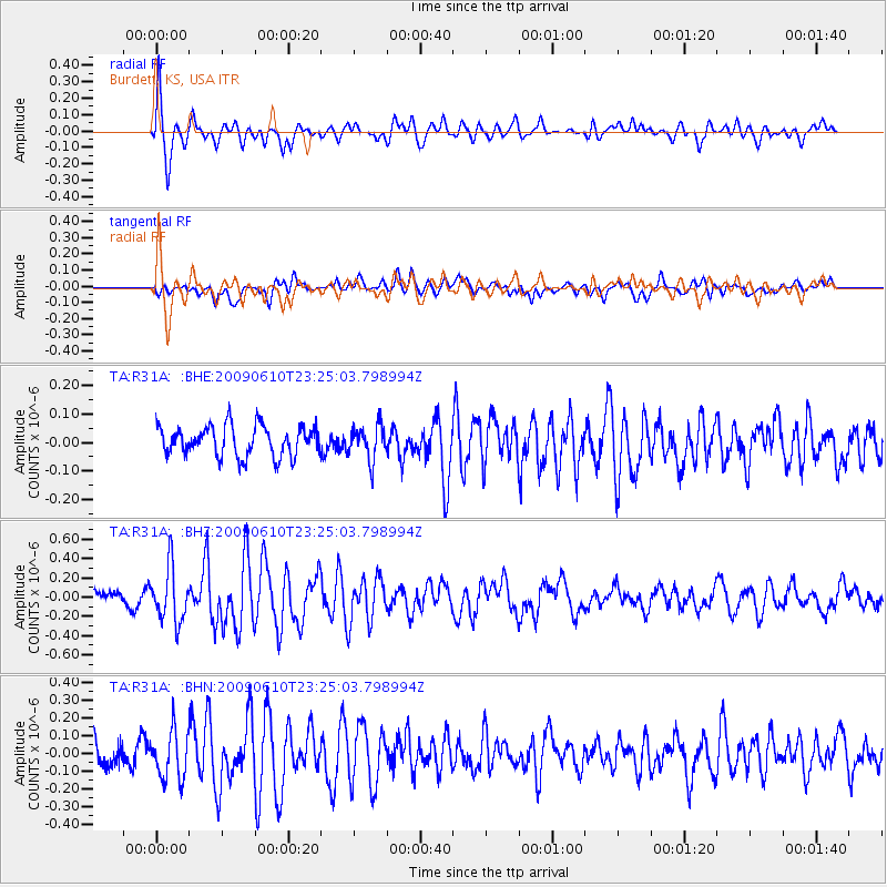
R31A Burdett, KS, USA - Earthquake Result Viewer
*The percent match for this event was below the threshold and hence no stack was calculated.
| Earthquake location: |
West Chile Rise |
| Earthquake latitude/longitude: |
-41.7/-84.0 |
| Earthquake time(UTC): |
2009/06/10 (161) 23:13:21 GMT |
| Earthquake Depth: |
10 km |
| Earthquake Magnitude: |
5.7 MB, 5.2 MS, 5.7 MW, 5.6 MW |
| Earthquake Catalog/Contributor: |
WHDF/NEIC |
|
| Network: |
TA USArray Transportable Network (new EarthScope stations) |
| Station: |
R31A Burdett, KS, USA |
| Lat/Lon: |
38.29 N/99.53 W |
| Elevation: |
667 m |
|
| Distance: |
80.9 deg |
| Az: |
347.677 deg |
| Baz: |
168.285 deg |
| Ray Param: |
$rayparam |
*The percent match for this event was below the threshold and hence was not used in the summary stack. |
|
| Radial Match: |
79.29696 % |
| Radial Bump: |
397 |
| Transverse Match: |
69.938805 % |
| Transverse Bump: |
400 |
| SOD ConfigId: |
2648 |
| Insert Time: |
2010-03-06 02:05:59.037 +0000 |
| GWidth: |
2.5 |
| Max Bumps: |
400 |
| Tol: |
0.001 |
|
Signal To Noise
| Channel | StoN | STA | LTA |
| TA:R31A: :BHZ:20090610T23:25:03.798994Z | 4.9842978 | 2.8052543E-7 | 5.6281834E-8 |
| TA:R31A: :BHN:20090610T23:25:03.798994Z | 2.1042924 | 1.32917E-7 | 6.316469E-8 |
| TA:R31A: :BHE:20090610T23:25:03.798994Z | 1.1343505 | 5.9301726E-8 | 5.227813E-8 |
| Arrivals |
| Ps | |
| PpPs | |
| PsPs/PpSs | |


