You are here: Home > Network List > TA - USArray Transportable Network (new EarthScope stations) Stations List
> Station P29M Windy Craggy, BC, CAN > Earthquake Result Viewer
P29M Windy Craggy, BC, CAN - Earthquake Result Viewer

| Earthquake location: |
Near East Coast Of Honshu, Japan |
| Earthquake latitude/longitude: |
37.4/141.6 |
| Earthquake time(UTC): |
2017/07/20 (201) 00:11:25 GMT |
| Earthquake Depth: |
35 km |
| Earthquake Magnitude: |
5.8 Mww |
| Earthquake Catalog/Contributor: |
NEIC PDE/us |
|
| Network: |
TA USArray Transportable Network (new EarthScope stations) |
| Station: |
P29M Windy Craggy, BC, CAN |
| Lat/Lon: |
59.63 N/137.74 W |
| Elevation: |
679 m |
|
| Distance: |
54.1 deg |
| Az: |
38.257 deg |
| Baz: |
284.029 deg |
| Ray Param: |
0.06561526 |
| Estimated Moho Depth: |
12.75 km |
| Estimated Crust Vp/Vs: |
1.75 |
| Assumed Crust Vp: |
6.566 km/s |
| Estimated Crust Vs: |
3.741 km/s |
| Estimated Crust Poisson's Ratio: |
0.26 |
|
| Radial Match: |
82.07647 % |
| Radial Bump: |
400 |
| Transverse Match: |
79.2533 % |
| Transverse Bump: |
400 |
| SOD ConfigId: |
13570011 |
| Insert Time: |
2019-04-28 10:34:20.597 +0000 |
| GWidth: |
2.5 |
| Max Bumps: |
400 |
| Tol: |
0.001 |
|
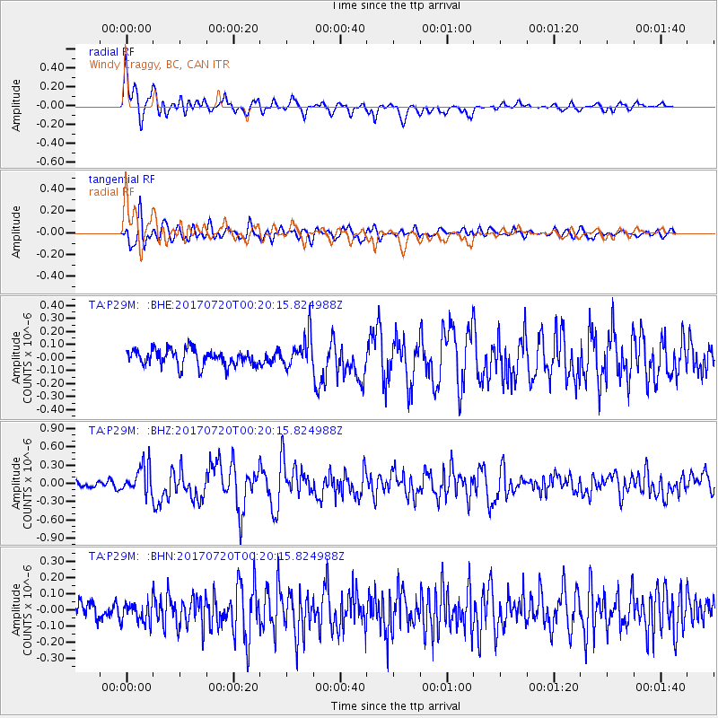
Signal To Noise
| Channel | StoN | STA | LTA |
| TA:P29M: :BHZ:20170720T00:20:15.824988Z | 4.5771003 | 2.3269627E-7 | 5.083923E-8 |
| TA:P29M: :BHN:20170720T00:20:15.824988Z | 1.2817312 | 6.3665084E-8 | 4.9671165E-8 |
| TA:P29M: :BHE:20170720T00:20:15.824988Z | 1.9679453 | 1.2346612E-7 | 6.273859E-8 |
| Arrivals |
| Ps | 1.6 SECOND |
| PpPs | 5.1 SECOND |
| PsPs/PpSs | 6.6 SECOND |


