You are here: Home > Network List > UW - Pacific Northwest Regional Seismic Network Stations List
> Station YACT Amboy, WA, USA > Earthquake Result Viewer
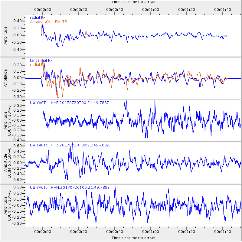
YACT Amboy, WA, USA - Earthquake Result Viewer
*The percent match for this event was below the threshold and hence no stack was calculated.
| Earthquake location: |
Near East Coast Of Honshu, Japan |
| Earthquake latitude/longitude: |
37.4/141.6 |
| Earthquake time(UTC): |
2017/07/20 (201) 00:11:25 GMT |
| Earthquake Depth: |
35 km |
| Earthquake Magnitude: |
5.8 Mww |
| Earthquake Catalog/Contributor: |
NEIC PDE/us |
|
| Network: |
UW Pacific Northwest Regional Seismic Network |
| Station: |
YACT Amboy, WA, USA |
| Lat/Lon: |
45.93 N/122.42 W |
| Elevation: |
211 m |
|
| Distance: |
67.9 deg |
| Az: |
48.494 deg |
| Baz: |
301.321 deg |
| Ray Param: |
$rayparam |
*The percent match for this event was below the threshold and hence was not used in the summary stack. |
|
| Radial Match: |
74.787865 % |
| Radial Bump: |
400 |
| Transverse Match: |
62.95105 % |
| Transverse Bump: |
400 |
| SOD ConfigId: |
13570011 |
| Insert Time: |
2019-04-28 10:35:40.142 +0000 |
| GWidth: |
2.5 |
| Max Bumps: |
400 |
| Tol: |
0.001 |
|
Signal To Noise
| Channel | StoN | STA | LTA |
| UW:YACT: :HHZ:20170720T00:21:49.788Z | 2.1691575 | 1.7188171E-7 | 7.923893E-8 |
| UW:YACT: :HHN:20170720T00:21:49.788Z | 0.72341764 | 5.894114E-8 | 8.147595E-8 |
| UW:YACT: :HHE:20170720T00:21:49.788Z | 1.1041901 | 6.65224E-8 | 6.024542E-8 |
| Arrivals |
| Ps | |
| PpPs | |
| PsPs/PpSs | |


