You are here: Home > Network List > TA - USArray Transportable Network (new EarthScope stations) Stations List
> Station O29A 4D Ranch, Culbertson, NE, USA > Earthquake Result Viewer
O29A 4D Ranch, Culbertson, NE, USA - Earthquake Result Viewer
| Earthquake location: |
Samoa Islands Region |
| Earthquake latitude/longitude: |
-15.2/-172.6 |
| Earthquake time(UTC): |
2009/08/30 (242) 14:51:32 GMT |
| Earthquake Depth: |
11 km |
| Earthquake Magnitude: |
6.4 MB, 6.3 MS, 6.6 MW, 6.6 MW |
| Earthquake Catalog/Contributor: |
WHDF/NEIC |
|
| Network: |
TA USArray Transportable Network (new EarthScope stations) |
| Station: |
O29A 4D Ranch, Culbertson, NE, USA |
| Lat/Lon: |
40.13 N/100.80 W |
| Elevation: |
826 m |
|
| Distance: |
86.3 deg |
| Az: |
46.869 deg |
| Baz: |
246.752 deg |
| Ray Param: |
0.044127133 |
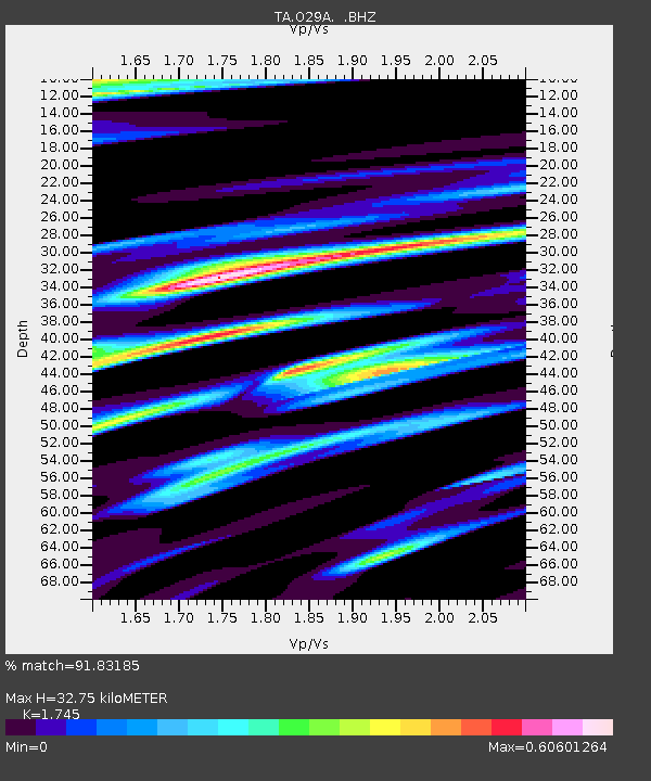
| Estimated Moho Depth: |
32.75 km |
| Estimated Crust Vp/Vs: |
1.75 |
| Assumed Crust Vp: |
6.483 km/s |
| Estimated Crust Vs: |
3.715 km/s |
| Estimated Crust Poisson's Ratio: |
0.26 |
|
| Radial Match: |
91.83185 % |
| Radial Bump: |
378 |
| Transverse Match: |
76.43516 % |
| Transverse Bump: |
400 |
| SOD ConfigId: |
2622 |
| Insert Time: |
2010-03-06 02:06:13.025 +0000 |
| GWidth: |
2.5 |
| Max Bumps: |
400 |
| Tol: |
0.001 |
|

Signal To Noise
| Channel | StoN | STA | LTA |
| TA:O29A: :BHZ:20090830T15:03:43.298997Z | 20.06667 | 2.5752124E-6 | 1.2833283E-7 |
| TA:O29A: :BHN:20090830T15:03:43.298997Z | 1.8165001 | 4.0903856E-7 | 2.2517949E-7 |
| TA:O29A: :BHE:20090830T15:03:43.298997Z | 3.7585983 | 9.876267E-7 | 2.6276462E-7 |
| Arrivals |
| Ps | 3.9 SECOND |
| PpPs | 14 SECOND |
| PsPs/PpSs | 17 SECOND |


