You are here: Home > Network List > TA - USArray Transportable Network (new EarthScope stations) Stations List
> Station O29A 4D Ranch, Culbertson, NE, USA > Earthquake Result Viewer
O29A 4D Ranch, Culbertson, NE, USA - Earthquake Result Viewer
| Earthquake location: |
Kuril Islands |
| Earthquake latitude/longitude: |
48.3/154.2 |
| Earthquake time(UTC): |
2009/09/10 (253) 02:46:50 GMT |
| Earthquake Depth: |
36 km |
| Earthquake Magnitude: |
6.0 MB, 5.5 MS, 6.0 MW, 5.8 MW |
| Earthquake Catalog/Contributor: |
WHDF/NEIC |
|
| Network: |
TA USArray Transportable Network (new EarthScope stations) |
| Station: |
O29A 4D Ranch, Culbertson, NE, USA |
| Lat/Lon: |
40.13 N/100.80 W |
| Elevation: |
826 m |
|
| Distance: |
69.8 deg |
| Az: |
52.109 deg |
| Baz: |
316.606 deg |
| Ray Param: |
0.05535333 |
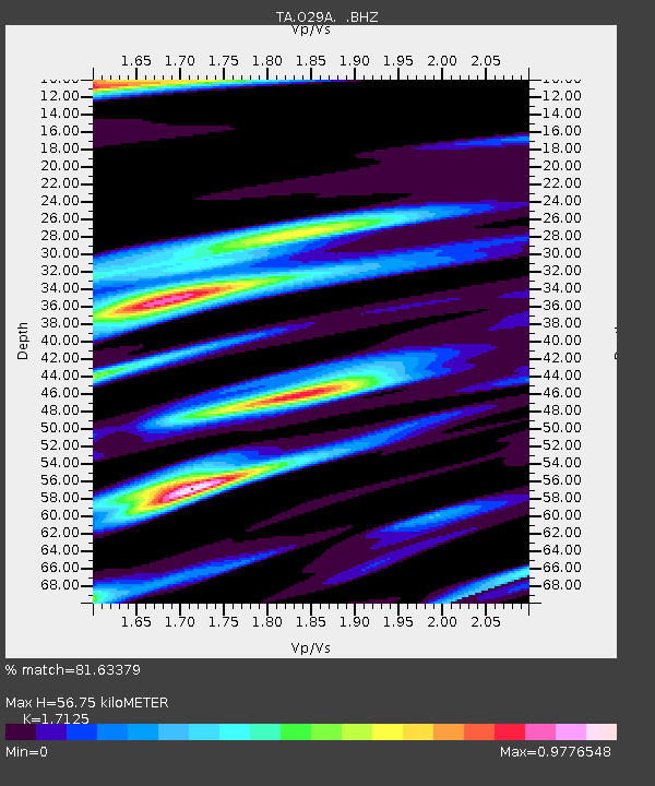
| Estimated Moho Depth: |
56.75 km |
| Estimated Crust Vp/Vs: |
1.71 |
| Assumed Crust Vp: |
6.483 km/s |
| Estimated Crust Vs: |
3.785 km/s |
| Estimated Crust Poisson's Ratio: |
0.24 |
|
| Radial Match: |
81.63379 % |
| Radial Bump: |
348 |
| Transverse Match: |
67.845856 % |
| Transverse Bump: |
400 |
| SOD ConfigId: |
2622 |
| Insert Time: |
2010-03-06 02:06:16.461 +0000 |
| GWidth: |
2.5 |
| Max Bumps: |
400 |
| Tol: |
0.001 |
|

Signal To Noise
| Channel | StoN | STA | LTA |
| TA:O29A: :BHZ:20090910T02:57:26.125024Z | 7.3300414 | 7.8061026E-7 | 1.0649466E-7 |
| TA:O29A: :BHN:20090910T02:57:26.125024Z | 1.8146644 | 4.2052667E-7 | 2.31738E-7 |
| TA:O29A: :BHE:20090910T02:57:26.125024Z | 2.6216161 | 3.8663637E-7 | 1.4748016E-7 |
| Arrivals |
| Ps | 6.5 SECOND |
| PpPs | 23 SECOND |
| PsPs/PpSs | 29 SECOND |


