You are here: Home > Network List > TA - USArray Transportable Network (new EarthScope stations) Stations List
> Station O29A 4D Ranch, Culbertson, NE, USA > Earthquake Result Viewer
O29A 4D Ranch, Culbertson, NE, USA - Earthquake Result Viewer
| Earthquake location: |
Samoa Islands Region |
| Earthquake latitude/longitude: |
-15.5/-172.1 |
| Earthquake time(UTC): |
2009/09/29 (272) 17:48:10 GMT |
| Earthquake Depth: |
18 km |
| Earthquake Magnitude: |
7.1 MB, 8.1 MS, 8.1 MW, 8.0 MW |
| Earthquake Catalog/Contributor: |
WHDF/NEIC |
|
| Network: |
TA USArray Transportable Network (new EarthScope stations) |
| Station: |
O29A 4D Ranch, Culbertson, NE, USA |
| Lat/Lon: |
40.13 N/100.80 W |
| Elevation: |
826 m |
|
| Distance: |
86.2 deg |
| Az: |
46.71 deg |
| Baz: |
246.244 deg |
| Ray Param: |
0.04422421 |
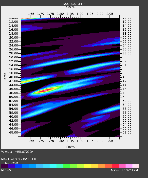
| Estimated Moho Depth: |
10.0 km |
| Estimated Crust Vp/Vs: |
1.61 |
| Assumed Crust Vp: |
6.483 km/s |
| Estimated Crust Vs: |
4.039 km/s |
| Estimated Crust Poisson's Ratio: |
0.18 |
|
| Radial Match: |
98.672134 % |
| Radial Bump: |
400 |
| Transverse Match: |
86.40229 % |
| Transverse Bump: |
400 |
| SOD ConfigId: |
2622 |
| Insert Time: |
2010-03-06 02:06:20.826 +0000 |
| GWidth: |
2.5 |
| Max Bumps: |
400 |
| Tol: |
0.001 |
|
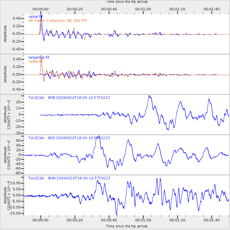
Signal To Noise
| Channel | StoN | STA | LTA |
| TA:O29A: :BHZ:20090929T18:00:19.575022Z | 9.932628 | 2.6687294E-6 | 2.6868312E-7 |
| TA:O29A: :BHN:20090929T18:00:19.575022Z | 1.8669246 | 3.8614468E-7 | 2.0683463E-7 |
| TA:O29A: :BHE:20090929T18:00:19.575022Z | 2.6201656 | 8.958745E-7 | 3.419152E-7 |
| Arrivals |
| Ps | 1.0 SECOND |
| PpPs | 3.9 SECOND |
| PsPs/PpSs | 4.9 SECOND |


