You are here: Home > Network List > TA - USArray Transportable Network (new EarthScope stations) Stations List
> Station O29A 4D Ranch, Culbertson, NE, USA > Earthquake Result Viewer
O29A 4D Ranch, Culbertson, NE, USA - Earthquake Result Viewer
| Earthquake location: |
Baffin Bay |
| Earthquake latitude/longitude: |
75.4/-72.5 |
| Earthquake time(UTC): |
2009/07/07 (188) 19:11:46 GMT |
| Earthquake Depth: |
19 km |
| Earthquake Magnitude: |
5.9 MB, 5.7 MS, 6.1 MW, 6.0 MW |
| Earthquake Catalog/Contributor: |
WHDF/NEIC |
|
| Network: |
TA USArray Transportable Network (new EarthScope stations) |
| Station: |
O29A 4D Ranch, Culbertson, NE, USA |
| Lat/Lon: |
40.13 N/100.80 W |
| Elevation: |
826 m |
|
| Distance: |
37.6 deg |
| Az: |
216.652 deg |
| Baz: |
11.428 deg |
| Ray Param: |
0.07603758 |
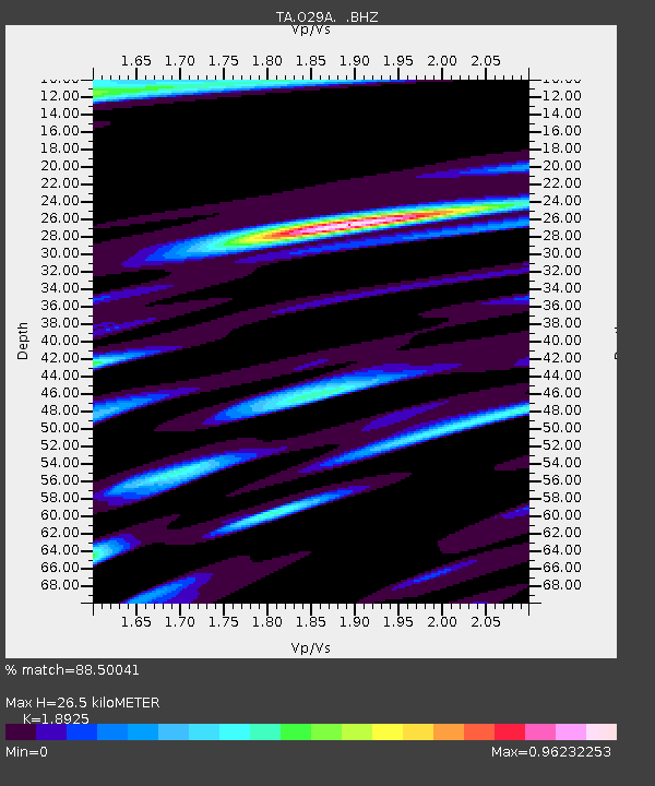
| Estimated Moho Depth: |
26.5 km |
| Estimated Crust Vp/Vs: |
1.89 |
| Assumed Crust Vp: |
6.483 km/s |
| Estimated Crust Vs: |
3.425 km/s |
| Estimated Crust Poisson's Ratio: |
0.31 |
|
| Radial Match: |
88.50041 % |
| Radial Bump: |
397 |
| Transverse Match: |
67.44594 % |
| Transverse Bump: |
400 |
| SOD ConfigId: |
2648 |
| Insert Time: |
2010-03-06 02:06:32.125 +0000 |
| GWidth: |
2.5 |
| Max Bumps: |
400 |
| Tol: |
0.001 |
|

Signal To Noise
| Channel | StoN | STA | LTA |
| TA:O29A: :BHZ:20090707T19:18:29.100015Z | 5.0128675 | 1.3826996E-6 | 2.7583005E-7 |
| TA:O29A: :BHN:20090707T19:18:29.100015Z | 4.525126 | 1.0264375E-6 | 2.268307E-7 |
| TA:O29A: :BHE:20090707T19:18:29.100015Z | 1.5545357 | 5.0556645E-7 | 3.2522019E-7 |
| Arrivals |
| Ps | 3.9 SECOND |
| PpPs | 11 SECOND |
| PsPs/PpSs | 15 SECOND |


