You are here: Home > Network List > 5H - Central Virginia and South Carolina seismic monitoring experiment Stations List
> Station PTTI Yanceyville, VA > Earthquake Result Viewer
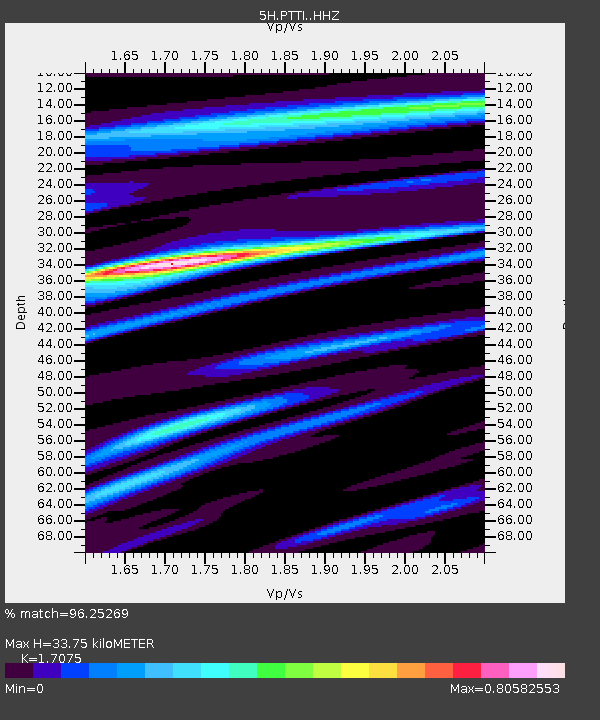
PTTI Yanceyville, VA - Earthquake Result Viewer
| Earthquake location: |
Dodecanese Islands, Greece |
| Earthquake latitude/longitude: |
36.9/27.5 |
| Earthquake time(UTC): |
2017/07/20 (201) 22:31:12 GMT |
| Earthquake Depth: |
10 km |
| Earthquake Magnitude: |
6.7 Mww |
| Earthquake Catalog/Contributor: |
NEIC PDE/us |
|
| Network: |
5H Central Virginia and South Carolina seismic monitoring experiment |
| Station: |
PTTI Yanceyville, VA |
| Lat/Lon: |
37.94 N/77.99 W |
| Elevation: |
98 m |
|
| Distance: |
78.6 deg |
| Az: |
308.972 deg |
| Baz: |
51.975 deg |
| Ray Param: |
0.04953627 |
| Estimated Moho Depth: |
33.75 km |
| Estimated Crust Vp/Vs: |
1.71 |
| Assumed Crust Vp: |
6.565 km/s |
| Estimated Crust Vs: |
3.845 km/s |
| Estimated Crust Poisson's Ratio: |
0.24 |
|
| Radial Match: |
96.25269 % |
| Radial Bump: |
343 |
| Transverse Match: |
88.50775 % |
| Transverse Bump: |
400 |
| SOD ConfigId: |
13570011 |
| Insert Time: |
2019-04-28 10:37:05.119 +0000 |
| GWidth: |
2.5 |
| Max Bumps: |
400 |
| Tol: |
0.001 |
|

Signal To Noise
| Channel | StoN | STA | LTA |
| 5H:PTTI: :HHZ:20170720T22:42:42.024976Z | 47.97946 | 3.0846213E-6 | 6.4290454E-8 |
| 5H:PTTI: :HHN:20170720T22:42:42.024976Z | 14.247416 | 5.149028E-7 | 3.6140086E-8 |
| 5H:PTTI: :HHE:20170720T22:42:42.024976Z | 23.891336 | 1.0612295E-6 | 4.4419004E-8 |
| Arrivals |
| Ps | 3.8 SECOND |
| PpPs | 13 SECOND |
| PsPs/PpSs | 17 SECOND |


