You are here: Home > Network List > TA - USArray Transportable Network (new EarthScope stations) Stations List
> Station O29A 4D Ranch, Culbertson, NE, USA > Earthquake Result Viewer
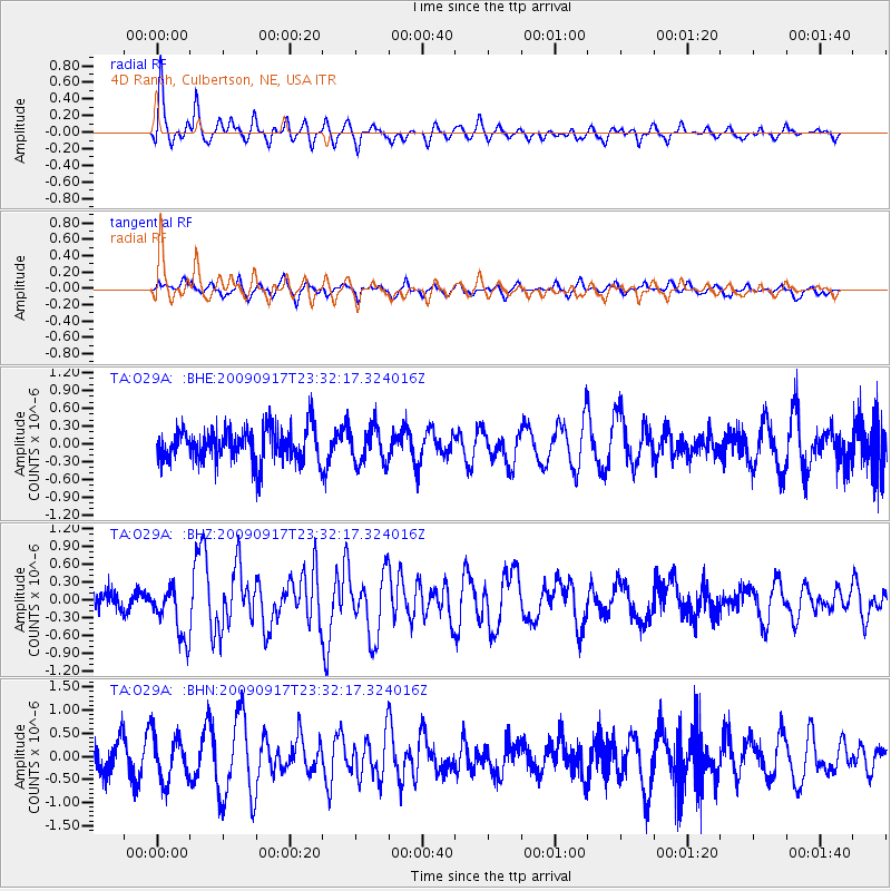
O29A 4D Ranch, Culbertson, NE, USA - Earthquake Result Viewer
*The percent match for this event was below the threshold and hence no stack was calculated.
| Earthquake location: |
Easter Island Region |
| Earthquake latitude/longitude: |
-29.1/-112.3 |
| Earthquake time(UTC): |
2009/09/17 (260) 23:21:38 GMT |
| Earthquake Depth: |
10 km |
| Earthquake Magnitude: |
5.7 MB, 6.0 MS, 6.2 MW, 6.2 MW |
| Earthquake Catalog/Contributor: |
WHDF/NEIC |
|
| Network: |
TA USArray Transportable Network (new EarthScope stations) |
| Station: |
O29A 4D Ranch, Culbertson, NE, USA |
| Lat/Lon: |
40.13 N/100.80 W |
| Elevation: |
826 m |
|
| Distance: |
69.7 deg |
| Az: |
9.353 deg |
| Baz: |
190.686 deg |
| Ray Param: |
$rayparam |
*The percent match for this event was below the threshold and hence was not used in the summary stack. |
|
| Radial Match: |
66.85751 % |
| Radial Bump: |
400 |
| Transverse Match: |
59.43166 % |
| Transverse Bump: |
400 |
| SOD ConfigId: |
2622 |
| Insert Time: |
2010-03-06 02:06:41.317 +0000 |
| GWidth: |
2.5 |
| Max Bumps: |
400 |
| Tol: |
0.001 |
|
Signal To Noise
| Channel | StoN | STA | LTA |
| TA:O29A: :BHZ:20090917T23:32:17.324016Z | 2.7792728 | 4.3691463E-7 | 1.5720467E-7 |
| TA:O29A: :BHN:20090917T23:32:17.324016Z | 1.2406048 | 4.8817435E-7 | 3.934971E-7 |
| TA:O29A: :BHE:20090917T23:32:17.324016Z | 1.0483001 | 2.9981493E-7 | 2.8600104E-7 |
| Arrivals |
| Ps | |
| PpPs | |
| PsPs/PpSs | |


