You are here: Home > Network List > GS - US Geological Survey Networks Stations List
> Station KAN11 Stewart Ranch, Harper County, KS, USA > Earthquake Result Viewer
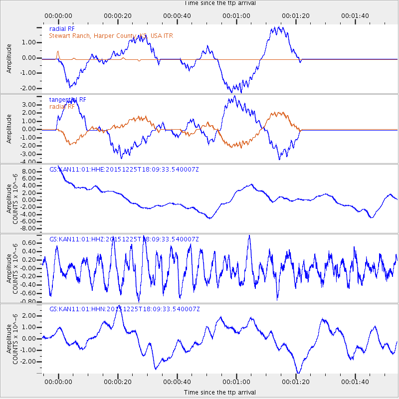
KAN11 Stewart Ranch, Harper County, KS, USA - Earthquake Result Viewer
*The percent match for this event was below the threshold and hence no stack was calculated.
| Earthquake location: |
West Chile Rise |
| Earthquake latitude/longitude: |
-40.7/-86.4 |
| Earthquake time(UTC): |
2015/12/25 (359) 17:58:04 GMT |
| Earthquake Depth: |
10 km |
| Earthquake Magnitude: |
5.8 MWW, 5.7 MWC, 5.7 MWB |
| Earthquake Catalog/Contributor: |
NEIC PDE/NEIC COMCAT |
|
| Network: |
GS US Geological Survey Networks |
| Station: |
KAN11 Stewart Ranch, Harper County, KS, USA |
| Lat/Lon: |
37.21 N/97.91 W |
| Elevation: |
410 m |
|
| Distance: |
78.3 deg |
| Az: |
350.662 deg |
| Baz: |
171.115 deg |
| Ray Param: |
$rayparam |
*The percent match for this event was below the threshold and hence was not used in the summary stack. |
|
| Radial Match: |
41.442394 % |
| Radial Bump: |
400 |
| Transverse Match: |
30.622768 % |
| Transverse Bump: |
400 |
| SOD ConfigId: |
1399611 |
| Insert Time: |
2016-01-27 18:57:43.582 +0000 |
| GWidth: |
2.5 |
| Max Bumps: |
400 |
| Tol: |
0.001 |
|
Signal To Noise
| Channel | StoN | STA | LTA |
| GS:KAN11:01:HHZ:20151225T18:09:33.540007Z | 1.0000169 | 2.2555182E-7 | 2.2554799E-7 |
| GS:KAN11:01:HHN:20151225T18:09:33.540007Z | 1.2981874 | 9.417241E-7 | 7.254146E-7 |
| GS:KAN11:01:HHE:20151225T18:09:33.540007Z | 2.5873103 | 5.1665106E-6 | 1.9968654E-6 |
| Arrivals |
| Ps | |
| PpPs | |
| PsPs/PpSs | |


