You are here: Home > Network List > BL - Brazilian Lithospheric Seismic Project (BLSP) Stations List
> Station PMNB Patos de Minas, MG > Earthquake Result Viewer
PMNB Patos de Minas, MG - Earthquake Result Viewer
| Earthquake location: |
Dodecanese Islands, Greece |
| Earthquake latitude/longitude: |
36.9/27.5 |
| Earthquake time(UTC): |
2017/07/20 (201) 22:31:12 GMT |
| Earthquake Depth: |
10 km |
| Earthquake Magnitude: |
6.7 Mww |
| Earthquake Catalog/Contributor: |
NEIC PDE/us |
|
| Network: |
BL Brazilian Lithospheric Seismic Project (BLSP) |
| Station: |
PMNB Patos de Minas, MG |
| Lat/Lon: |
18.54 S/46.44 W |
| Elevation: |
950 m |
|
| Distance: |
88.8 deg |
| Az: |
245.746 deg |
| Baz: |
50.341 deg |
| Ray Param: |
0.04234635 |
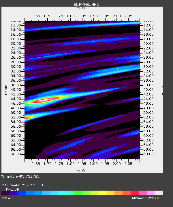
| Estimated Moho Depth: |
44.25 km |
| Estimated Crust Vp/Vs: |
1.69 |
| Assumed Crust Vp: |
6.419 km/s |
| Estimated Crust Vs: |
3.798 km/s |
| Estimated Crust Poisson's Ratio: |
0.23 |
|
| Radial Match: |
95.752785 % |
| Radial Bump: |
255 |
| Transverse Match: |
82.306786 % |
| Transverse Bump: |
212 |
| SOD ConfigId: |
13570011 |
| Insert Time: |
2019-04-28 10:38:55.796 +0000 |
| GWidth: |
2.5 |
| Max Bumps: |
400 |
| Tol: |
0.001 |
|

Signal To Noise
| Channel | StoN | STA | LTA |
| BL:PMNB: :HHZ:20170720T22:43:33.78999Z | 12.462158 | 2.5270563E-6 | 2.0277838E-7 |
| BL:PMNB: :HHN:20170720T22:43:33.78999Z | 2.1377597 | 4.3966386E-7 | 2.056657E-7 |
| BL:PMNB: :HHE:20170720T22:43:33.78999Z | 4.456211 | 6.2356094E-7 | 1.3993075E-7 |
| Arrivals |
| Ps | 4.9 SECOND |
| PpPs | 18 SECOND |
| PsPs/PpSs | 23 SECOND |


