You are here: Home > Network List > TA - USArray Transportable Network (new EarthScope stations) Stations List
> Station K29A Lazy Trails Angus Ranch, Wood Lake, NE, USA > Earthquake Result Viewer
K29A Lazy Trails Angus Ranch, Wood Lake, NE, USA - Earthquake Result Viewer
| Earthquake location: |
Off Coast Of Costa Rica |
| Earthquake latitude/longitude: |
7.9/-85.6 |
| Earthquake time(UTC): |
2009/08/13 (225) 09:37:35 GMT |
| Earthquake Depth: |
10 km |
| Earthquake Magnitude: |
5.8 MW, 5.3 MB |
| Earthquake Catalog/Contributor: |
WHDF/NEIC |
|
| Network: |
TA USArray Transportable Network (new EarthScope stations) |
| Station: |
K29A Lazy Trails Angus Ranch, Wood Lake, NE, USA |
| Lat/Lon: |
42.76 N/100.32 W |
| Elevation: |
840 m |
|
| Distance: |
37.0 deg |
| Az: |
341.93 deg |
| Baz: |
155.343 deg |
| Ray Param: |
0.07637125 |
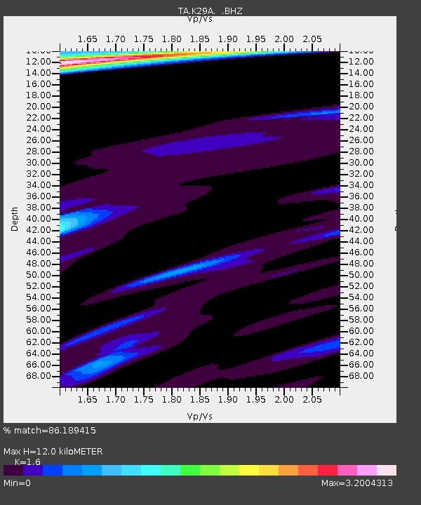
| Estimated Moho Depth: |
12.0 km |
| Estimated Crust Vp/Vs: |
1.60 |
| Assumed Crust Vp: |
6.483 km/s |
| Estimated Crust Vs: |
4.052 km/s |
| Estimated Crust Poisson's Ratio: |
0.18 |
|
| Radial Match: |
86.189415 % |
| Radial Bump: |
301 |
| Transverse Match: |
62.324715 % |
| Transverse Bump: |
397 |
| SOD ConfigId: |
2622 |
| Insert Time: |
2010-03-06 02:07:00.813 +0000 |
| GWidth: |
2.5 |
| Max Bumps: |
400 |
| Tol: |
0.001 |
|

Signal To Noise
| Channel | StoN | STA | LTA |
| TA:K29A: :BHZ:20090813T09:44:14.175012Z | 7.7905736 | 5.2508994E-7 | 6.740068E-8 |
| TA:K29A: :BHN:20090813T09:44:14.175012Z | 3.4715235 | 6.2514584E-7 | 1.8007823E-7 |
| TA:K29A: :BHE:20090813T09:44:14.175012Z | 1.4597304 | 2.1996375E-7 | 1.5068794E-7 |
| Arrivals |
| Ps | 1.2 SECOND |
| PpPs | 4.4 SECOND |
| PsPs/PpSs | 5.6 SECOND |


