You are here: Home > Network List > TA - USArray Transportable Network (new EarthScope stations) Stations List
> Station K29A Lazy Trails Angus Ranch, Wood Lake, NE, USA > Earthquake Result Viewer
K29A Lazy Trails Angus Ranch, Wood Lake, NE, USA - Earthquake Result Viewer
| Earthquake location: |
Samoa Islands Region |
| Earthquake latitude/longitude: |
-15.2/-172.6 |
| Earthquake time(UTC): |
2009/08/30 (242) 14:51:32 GMT |
| Earthquake Depth: |
11 km |
| Earthquake Magnitude: |
6.4 MB, 6.3 MS, 6.6 MW, 6.6 MW |
| Earthquake Catalog/Contributor: |
WHDF/NEIC |
|
| Network: |
TA USArray Transportable Network (new EarthScope stations) |
| Station: |
K29A Lazy Trails Angus Ranch, Wood Lake, NE, USA |
| Lat/Lon: |
42.76 N/100.32 W |
| Elevation: |
840 m |
|
| Distance: |
87.7 deg |
| Az: |
44.586 deg |
| Baz: |
246.949 deg |
| Ray Param: |
0.04313585 |
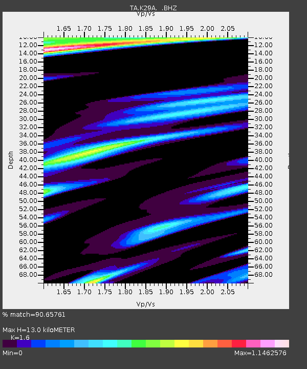
| Estimated Moho Depth: |
13.0 km |
| Estimated Crust Vp/Vs: |
1.60 |
| Assumed Crust Vp: |
6.483 km/s |
| Estimated Crust Vs: |
4.052 km/s |
| Estimated Crust Poisson's Ratio: |
0.18 |
|
| Radial Match: |
90.65761 % |
| Radial Bump: |
400 |
| Transverse Match: |
72.05561 % |
| Transverse Bump: |
400 |
| SOD ConfigId: |
2622 |
| Insert Time: |
2010-03-06 02:07:04.158 +0000 |
| GWidth: |
2.5 |
| Max Bumps: |
400 |
| Tol: |
0.001 |
|
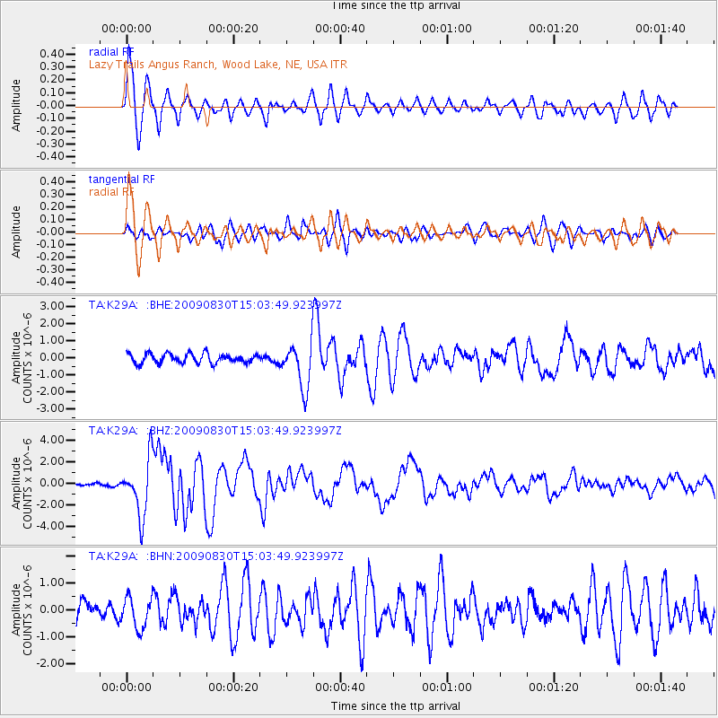
Signal To Noise
| Channel | StoN | STA | LTA |
| TA:K29A: :BHZ:20090830T15:03:49.923997Z | 21.480879 | 2.634528E-6 | 1.2264528E-7 |
| TA:K29A: :BHN:20090830T15:03:49.923997Z | 1.6662743 | 5.8558044E-7 | 3.5143097E-7 |
| TA:K29A: :BHE:20090830T15:03:49.923997Z | 4.927022 | 1.3535038E-6 | 2.7471032E-7 |
| Arrivals |
| Ps | 1.2 SECOND |
| PpPs | 5.1 SECOND |
| PsPs/PpSs | 6.3 SECOND |


