You are here: Home > Network List > IU - Global Seismograph Network (GSN - IRIS/USGS) Stations List
> Station MACI Morro de la Arena, Canary Islands > Earthquake Result Viewer
MACI Morro de la Arena, Canary Islands - Earthquake Result Viewer
| Earthquake location: |
Dodecanese Islands, Greece |
| Earthquake latitude/longitude: |
36.9/27.5 |
| Earthquake time(UTC): |
2017/07/20 (201) 22:31:12 GMT |
| Earthquake Depth: |
10 km |
| Earthquake Magnitude: |
6.7 Mww |
| Earthquake Catalog/Contributor: |
NEIC PDE/us |
|
| Network: |
IU Global Seismograph Network (GSN - IRIS/USGS) |
| Station: |
MACI Morro de la Arena, Canary Islands |
| Lat/Lon: |
28.25 N/16.51 W |
| Elevation: |
1674 m |
|
| Distance: |
37.8 deg |
| Az: |
269.735 deg |
| Baz: |
65.239 deg |
| Ray Param: |
0.07595004 |
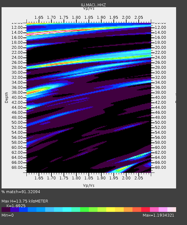
| Estimated Moho Depth: |
13.75 km |
| Estimated Crust Vp/Vs: |
1.69 |
| Assumed Crust Vp: |
4.662 km/s |
| Estimated Crust Vs: |
2.755 km/s |
| Estimated Crust Poisson's Ratio: |
0.23 |
|
| Radial Match: |
91.32094 % |
| Radial Bump: |
336 |
| Transverse Match: |
75.11693 % |
| Transverse Bump: |
400 |
| SOD ConfigId: |
13570011 |
| Insert Time: |
2019-04-28 10:40:52.280 +0000 |
| GWidth: |
2.5 |
| Max Bumps: |
400 |
| Tol: |
0.001 |
|

Signal To Noise
| Channel | StoN | STA | LTA |
| IU:MACI: :HHZ:20170720T22:37:56.690015Z | 7.0984945 | 4.204195E-6 | 5.9226574E-7 |
| IU:MACI: :HHN:20170720T22:37:56.690015Z | 2.2722318 | 1.0418546E-6 | 4.5851598E-7 |
| IU:MACI: :HHE:20170720T22:37:56.690015Z | 3.6457047 | 1.8579746E-6 | 5.096338E-7 |
| Arrivals |
| Ps | 2.1 SECOND |
| PpPs | 7.6 SECOND |
| PsPs/PpSs | 9.8 SECOND |


