You are here: Home > Network List > KS - Korea National Seismograph Network- KMA Stations List
> Station NAWB Namwon, South Korea > Earthquake Result Viewer
NAWB Namwon, South Korea - Earthquake Result Viewer
| Earthquake location: |
Dodecanese Islands, Greece |
| Earthquake latitude/longitude: |
36.9/27.5 |
| Earthquake time(UTC): |
2017/07/20 (201) 22:31:12 GMT |
| Earthquake Depth: |
10 km |
| Earthquake Magnitude: |
6.7 Mww |
| Earthquake Catalog/Contributor: |
NEIC PDE/us |
|
| Network: |
KS Korea National Seismograph Network- KMA |
| Station: |
NAWB Namwon, South Korea |
| Lat/Lon: |
35.42 N/127.40 E |
| Elevation: |
176 m |
|
| Distance: |
76.6 deg |
| Az: |
55.806 deg |
| Baz: |
305.777 deg |
| Ray Param: |
0.050911825 |
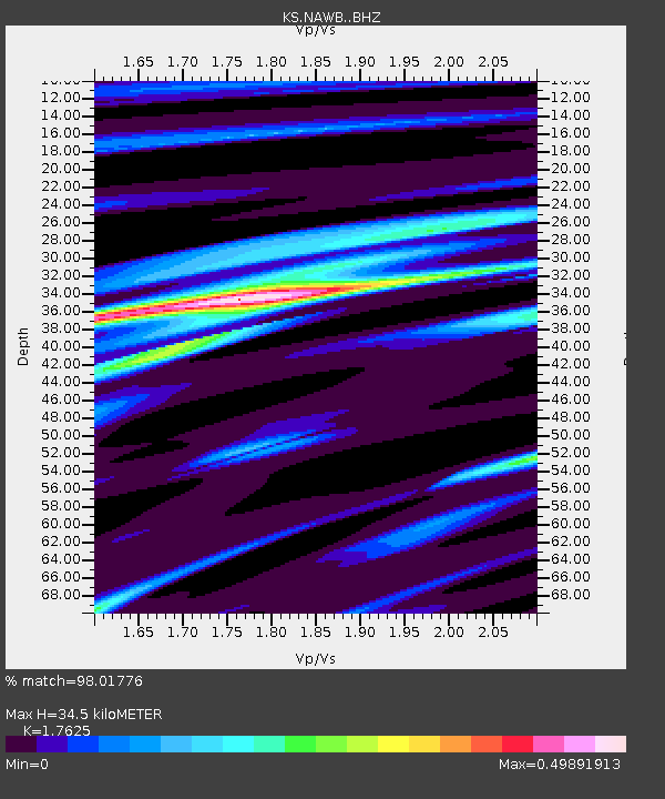
| Estimated Moho Depth: |
34.5 km |
| Estimated Crust Vp/Vs: |
1.76 |
| Assumed Crust Vp: |
6.459 km/s |
| Estimated Crust Vs: |
3.665 km/s |
| Estimated Crust Poisson's Ratio: |
0.26 |
|
| Radial Match: |
98.01776 % |
| Radial Bump: |
163 |
| Transverse Match: |
95.6346 % |
| Transverse Bump: |
400 |
| SOD ConfigId: |
13570011 |
| Insert Time: |
2019-04-28 10:41:24.285 +0000 |
| GWidth: |
2.5 |
| Max Bumps: |
400 |
| Tol: |
0.001 |
|

Signal To Noise
| Channel | StoN | STA | LTA |
| KS:NAWB: :BHZ:20170720T22:42:31.018994Z | 37.06149 | 3.8817207E-6 | 1.047373E-7 |
| KS:NAWB: :BHN:20170720T22:42:31.018994Z | 1.8574644 | 1.0765408E-7 | 5.7957546E-8 |
| KS:NAWB: :BHE:20170720T22:42:31.018994Z | 28.54738 | 1.500179E-6 | 5.2550497E-8 |
| Arrivals |
| Ps | 4.2 SECOND |
| PpPs | 14 SECOND |
| PsPs/PpSs | 18 SECOND |


