You are here: Home > Network List > LD - Lamont-Doherty Cooperative Seismographic Network Stations List
> Station MSNJ Montclair State University, NJ > Earthquake Result Viewer
MSNJ Montclair State University, NJ - Earthquake Result Viewer
| Earthquake location: |
Dodecanese Islands, Greece |
| Earthquake latitude/longitude: |
36.9/27.5 |
| Earthquake time(UTC): |
2017/07/20 (201) 22:31:12 GMT |
| Earthquake Depth: |
10 km |
| Earthquake Magnitude: |
6.7 Mww |
| Earthquake Catalog/Contributor: |
NEIC PDE/us |
|
| Network: |
LD Lamont-Doherty Cooperative Seismographic Network |
| Station: |
MSNJ Montclair State University, NJ |
| Lat/Lon: |
40.88 N/74.18 W |
| Elevation: |
132 m |
|
| Distance: |
74.5 deg |
| Az: |
309.579 deg |
| Baz: |
54.524 deg |
| Ray Param: |
0.05231026 |
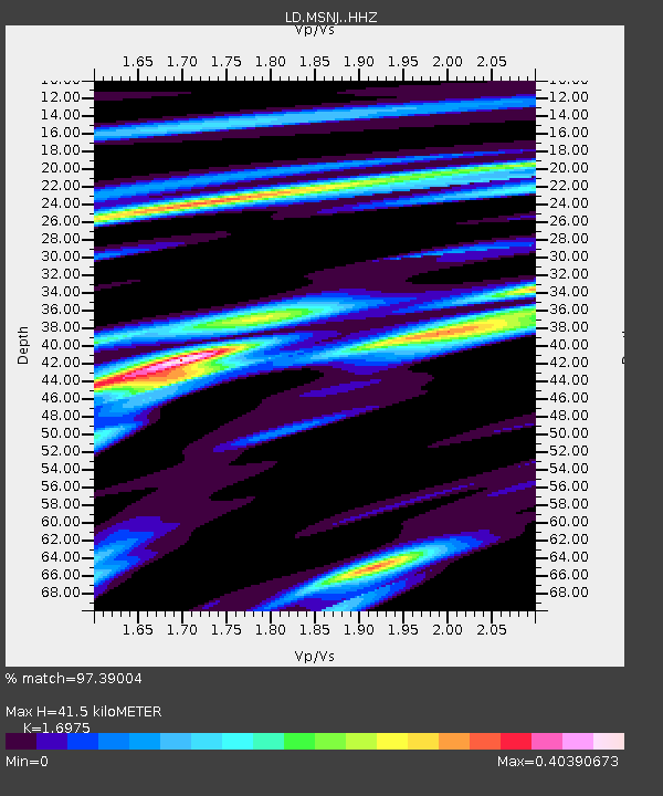
| Estimated Moho Depth: |
41.5 km |
| Estimated Crust Vp/Vs: |
1.70 |
| Assumed Crust Vp: |
6.283 km/s |
| Estimated Crust Vs: |
3.702 km/s |
| Estimated Crust Poisson's Ratio: |
0.23 |
|
| Radial Match: |
97.39004 % |
| Radial Bump: |
183 |
| Transverse Match: |
85.79132 % |
| Transverse Bump: |
400 |
| SOD ConfigId: |
13570011 |
| Insert Time: |
2019-04-28 10:41:43.177 +0000 |
| GWidth: |
2.5 |
| Max Bumps: |
400 |
| Tol: |
0.001 |
|

Signal To Noise
| Channel | StoN | STA | LTA |
| LD:MSNJ: :HHZ:20170720T22:42:18.760022Z | 30.658503 | 3.1180848E-6 | 1.01703755E-7 |
| LD:MSNJ: :HHN:20170720T22:42:18.760022Z | 3.3243735 | 5.3267485E-7 | 1.6023316E-7 |
| LD:MSNJ: :HHE:20170720T22:42:18.760022Z | 5.890885 | 1.4773367E-6 | 2.507835E-7 |
| Arrivals |
| Ps | 4.8 SECOND |
| PpPs | 17 SECOND |
| PsPs/PpSs | 22 SECOND |


