You are here: Home > Network List > LD - Lamont-Doherty Cooperative Seismographic Network Stations List
> Station PAL Palisades, New York > Earthquake Result Viewer
PAL Palisades, New York - Earthquake Result Viewer
| Earthquake location: |
Dodecanese Islands, Greece |
| Earthquake latitude/longitude: |
36.9/27.5 |
| Earthquake time(UTC): |
2017/07/20 (201) 22:31:12 GMT |
| Earthquake Depth: |
10 km |
| Earthquake Magnitude: |
6.7 Mww |
| Earthquake Catalog/Contributor: |
NEIC PDE/us |
|
| Network: |
LD Lamont-Doherty Cooperative Seismographic Network |
| Station: |
PAL Palisades, New York |
| Lat/Lon: |
41.01 N/73.91 W |
| Elevation: |
66 m |
|
| Distance: |
74.2 deg |
| Az: |
309.557 deg |
| Baz: |
54.697 deg |
| Ray Param: |
0.052471127 |
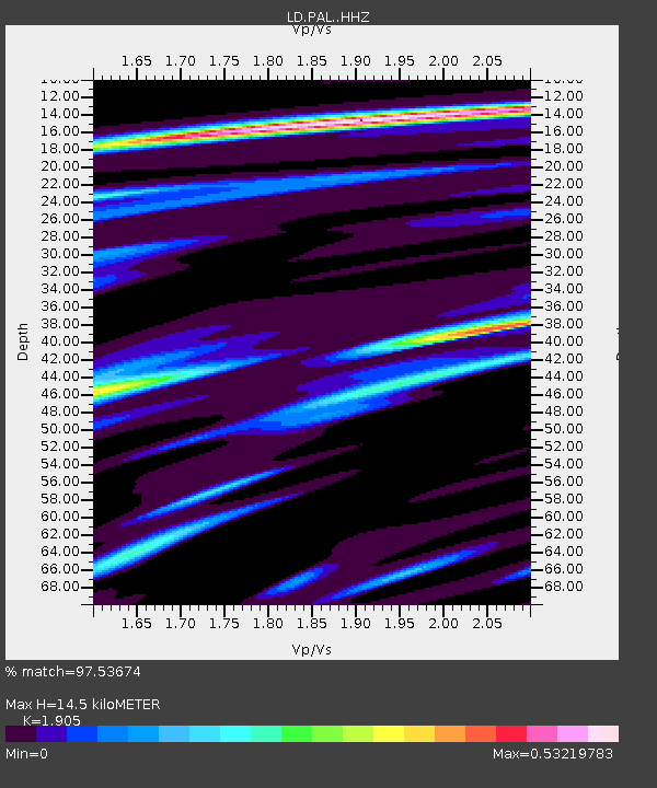
| Estimated Moho Depth: |
14.5 km |
| Estimated Crust Vp/Vs: |
1.90 |
| Assumed Crust Vp: |
6.472 km/s |
| Estimated Crust Vs: |
3.397 km/s |
| Estimated Crust Poisson's Ratio: |
0.31 |
|
| Radial Match: |
97.53674 % |
| Radial Bump: |
239 |
| Transverse Match: |
91.46693 % |
| Transverse Bump: |
384 |
| SOD ConfigId: |
13570011 |
| Insert Time: |
2019-04-28 10:41:47.217 +0000 |
| GWidth: |
2.5 |
| Max Bumps: |
400 |
| Tol: |
0.001 |
|

Signal To Noise
| Channel | StoN | STA | LTA |
| LD:PAL: :HHZ:20170720T22:42:17.367993Z | 39.795174 | 3.1672432E-6 | 7.9588624E-8 |
| LD:PAL: :HHN:20170720T22:42:17.367993Z | 9.361607 | 6.7110795E-7 | 7.168726E-8 |
| LD:PAL: :HHE:20170720T22:42:17.367993Z | 19.419926 | 1.2288003E-6 | 6.327523E-8 |
| Arrivals |
| Ps | 2.1 SECOND |
| PpPs | 6.3 SECOND |
| PsPs/PpSs | 8.4 SECOND |


