You are here: Home > Network List > N4 - Central and EAstern US Network Stations List
> Station E43A Lone Tree Farm, Eben Junction, MI, USA > Earthquake Result Viewer
E43A Lone Tree Farm, Eben Junction, MI, USA - Earthquake Result Viewer
| Earthquake location: |
Dodecanese Islands, Greece |
| Earthquake latitude/longitude: |
36.9/27.5 |
| Earthquake time(UTC): |
2017/07/20 (201) 22:31:12 GMT |
| Earthquake Depth: |
10 km |
| Earthquake Magnitude: |
6.7 Mww |
| Earthquake Catalog/Contributor: |
NEIC PDE/us |
|
| Network: |
N4 Central and EAstern US Network |
| Station: |
E43A Lone Tree Farm, Eben Junction, MI, USA |
| Lat/Lon: |
46.38 N/87.00 W |
| Elevation: |
303 m |
|
| Distance: |
78.3 deg |
| Az: |
319.943 deg |
| Baz: |
48.128 deg |
| Ray Param: |
0.04971496 |
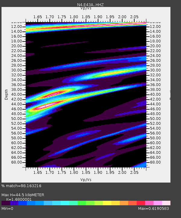
| Estimated Moho Depth: |
44.5 km |
| Estimated Crust Vp/Vs: |
1.68 |
| Assumed Crust Vp: |
6.472 km/s |
| Estimated Crust Vs: |
3.852 km/s |
| Estimated Crust Poisson's Ratio: |
0.23 |
|
| Radial Match: |
98.163216 % |
| Radial Bump: |
213 |
| Transverse Match: |
84.9491 % |
| Transverse Bump: |
400 |
| SOD ConfigId: |
13570011 |
| Insert Time: |
2019-04-28 10:42:21.040 +0000 |
| GWidth: |
2.5 |
| Max Bumps: |
400 |
| Tol: |
0.001 |
|

Signal To Noise
| Channel | StoN | STA | LTA |
| N4:E43A: :HHZ:20170720T22:42:40.630017Z | 47.016514 | 3.070973E-6 | 6.5316904E-8 |
| N4:E43A: :HHN:20170720T22:42:40.630017Z | 15.426274 | 8.7730757E-7 | 5.6871E-8 |
| N4:E43A: :HHE:20170720T22:42:40.630017Z | 7.05807 | 8.019369E-7 | 1.1361985E-7 |
| Arrivals |
| Ps | 4.8 SECOND |
| PpPs | 18 SECOND |
| PsPs/PpSs | 23 SECOND |


