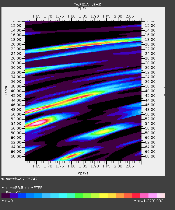
P31A Stockton, KS, USA - Earthquake Result Viewer
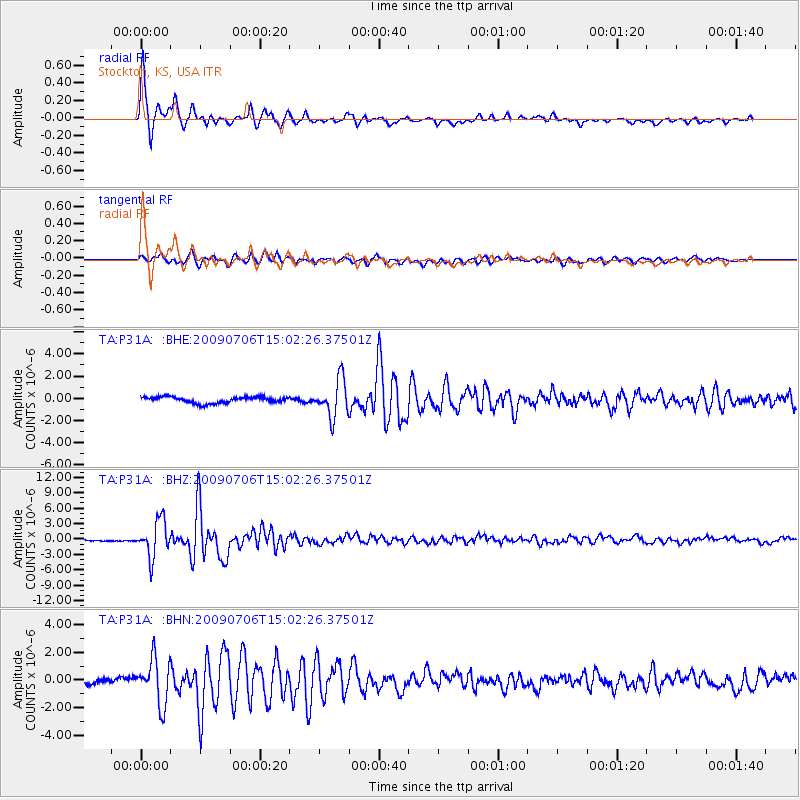
Earthquake location: Rat Islands, Aleutian Islands
Earthquake latitude/longitude: 50.4/177.0
Earthquake time(UTC): 2009/07/06 (187) 14:53:12 GMT
Earthquake Depth: 22 km
Earthquake Magnitude: 6.0 MB, 5.8 MS, 6.1 MW, 6.0 MW
Earthquake Catalog/Contributor: WHDF/NEIC
Network: TA USArray Transportable Network (new EarthScope stations)
Station: P31A Stockton, KS, USA
Lat/Lon: 39.52 N/99.38 W
Elevation: 665 m
Distance: 57.2 deg
Az: 66.181 deg
Baz: 310.856 deg
Ray Param: 0.06363375
Estimated Moho Depth: 53.5 km
Estimated Crust Vp/Vs: 1.65
Assumed Crust Vp: 6.483 km/s
Estimated Crust Vs: 3.917 km/s
Estimated Crust Poisson's Ratio: 0.21
Radial Match: 97.25747 %
Radial Bump: 297
Transverse Match: 91.90366 %
Transverse Bump: 400
SOD ConfigId: 2648
Insert Time: 2010-03-06 02:08:29.733 +0000
GWidth: 2.5
Max Bumps: 400
Tol: 0.001

Signal To Noise

ChannelStoNSTALTA
TA:P31A: :BHZ:20090706T15:02:26.37501Z18.1544693.513878E-61.9355444E-7
TA:P31A: :BHN:20090706T15:02:26.37501Z8.8692751.6250947E-61.8322746E-7
TA:P31A: :BHE:20090706T15:02:26.37501Z6.0806191.6682919E-62.743622E-7
Arrivals
Ps5.7 SECOND
PpPs21 SECOND
PsPs/PpSs26 SECOND