You are here: Home > Network List > N4 - Central and EAstern US Network Stations List
> Station K62A Royalston, MA, USA > Earthquake Result Viewer
K62A Royalston, MA, USA - Earthquake Result Viewer
| Earthquake location: |
Dodecanese Islands, Greece |
| Earthquake latitude/longitude: |
36.9/27.5 |
| Earthquake time(UTC): |
2017/07/20 (201) 22:31:12 GMT |
| Earthquake Depth: |
10 km |
| Earthquake Magnitude: |
6.7 Mww |
| Earthquake Catalog/Contributor: |
NEIC PDE/us |
|
| Network: |
N4 Central and EAstern US Network |
| Station: |
K62A Royalston, MA, USA |
| Lat/Lon: |
42.67 N/72.23 W |
| Elevation: |
289 m |
|
| Distance: |
72.3 deg |
| Az: |
310.239 deg |
| Baz: |
56.005 deg |
| Ray Param: |
0.053777628 |
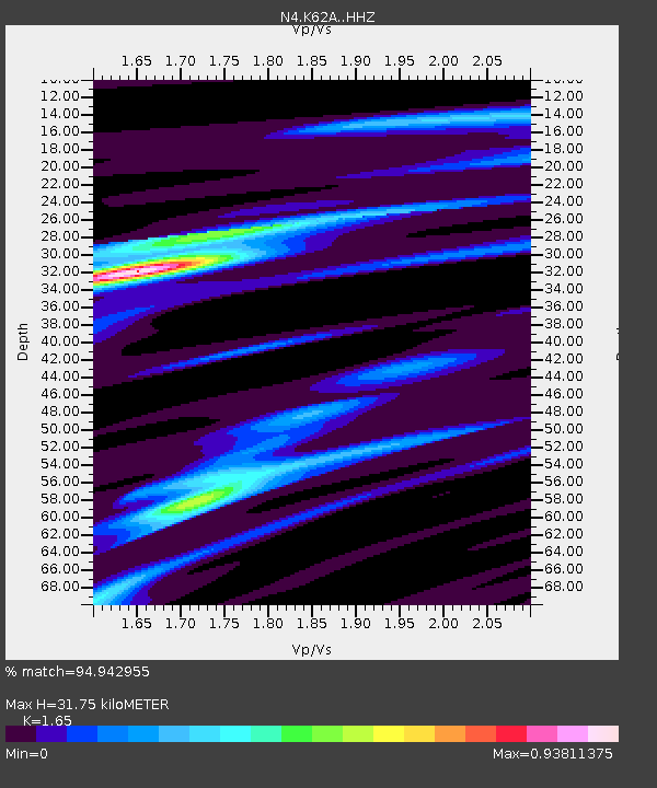
| Estimated Moho Depth: |
31.75 km |
| Estimated Crust Vp/Vs: |
1.65 |
| Assumed Crust Vp: |
6.419 km/s |
| Estimated Crust Vs: |
3.89 km/s |
| Estimated Crust Poisson's Ratio: |
0.21 |
|
| Radial Match: |
94.942955 % |
| Radial Bump: |
271 |
| Transverse Match: |
82.75053 % |
| Transverse Bump: |
400 |
| SOD ConfigId: |
13570011 |
| Insert Time: |
2019-04-28 10:42:47.196 +0000 |
| GWidth: |
2.5 |
| Max Bumps: |
400 |
| Tol: |
0.001 |
|

Signal To Noise
| Channel | StoN | STA | LTA |
| N4:K62A: :HHZ:20170720T22:42:05.760022Z | 41.18539 | 3.6069096E-6 | 8.75774E-8 |
| N4:K62A: :HHN:20170720T22:42:05.760022Z | 14.176734 | 7.760276E-7 | 5.4739516E-8 |
| N4:K62A: :HHE:20170720T22:42:05.760022Z | 20.66084 | 1.4655334E-6 | 7.0932906E-8 |
| Arrivals |
| Ps | 3.3 SECOND |
| PpPs | 13 SECOND |
| PsPs/PpSs | 16 SECOND |


