You are here: Home > Network List > N4 - Central and EAstern US Network Stations List
> Station L64A Middleborough, MA, USA > Earthquake Result Viewer
L64A Middleborough, MA, USA - Earthquake Result Viewer
| Earthquake location: |
Dodecanese Islands, Greece |
| Earthquake latitude/longitude: |
36.9/27.5 |
| Earthquake time(UTC): |
2017/07/20 (201) 22:31:12 GMT |
| Earthquake Depth: |
10 km |
| Earthquake Magnitude: |
6.7 Mww |
| Earthquake Catalog/Contributor: |
NEIC PDE/us |
|
| Network: |
N4 Central and EAstern US Network |
| Station: |
L64A Middleborough, MA, USA |
| Lat/Lon: |
41.94 N/70.84 W |
| Elevation: |
17 m |
|
| Distance: |
71.8 deg |
| Az: |
308.998 deg |
| Baz: |
56.558 deg |
| Ray Param: |
0.054082826 |
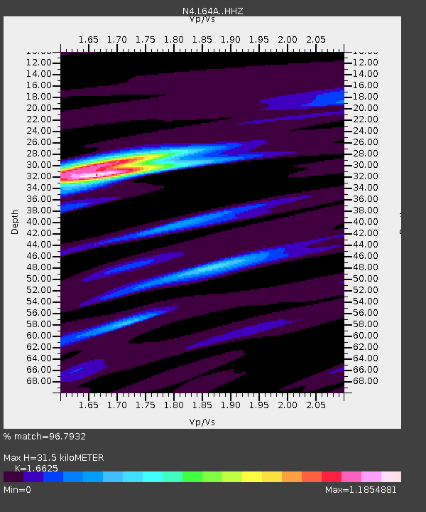
| Estimated Moho Depth: |
31.5 km |
| Estimated Crust Vp/Vs: |
1.66 |
| Assumed Crust Vp: |
6.472 km/s |
| Estimated Crust Vs: |
3.893 km/s |
| Estimated Crust Poisson's Ratio: |
0.22 |
|
| Radial Match: |
96.7932 % |
| Radial Bump: |
284 |
| Transverse Match: |
85.54041 % |
| Transverse Bump: |
400 |
| SOD ConfigId: |
13570011 |
| Insert Time: |
2019-04-28 10:42:53.827 +0000 |
| GWidth: |
2.5 |
| Max Bumps: |
400 |
| Tol: |
0.001 |
|

Signal To Noise
| Channel | StoN | STA | LTA |
| N4:L64A: :HHZ:20170720T22:42:03.02998Z | 32.687756 | 3.5233688E-6 | 1.0778864E-7 |
| N4:L64A: :HHN:20170720T22:42:03.02998Z | 11.937816 | 8.2958206E-7 | 6.9491946E-8 |
| N4:L64A: :HHE:20170720T22:42:03.02998Z | 19.824755 | 1.353733E-6 | 6.8284976E-8 |
| Arrivals |
| Ps | 3.4 SECOND |
| PpPs | 12 SECOND |
| PsPs/PpSs | 16 SECOND |


