You are here: Home > Network List > N4 - Central and EAstern US Network Stations List
> Station M44A Midewin, Midewin Nat. Tallgrass Prarie, IL, USA > Earthquake Result Viewer
M44A Midewin, Midewin Nat. Tallgrass Prarie, IL, USA - Earthquake Result Viewer
| Earthquake location: |
Dodecanese Islands, Greece |
| Earthquake latitude/longitude: |
36.9/27.5 |
| Earthquake time(UTC): |
2017/07/20 (201) 22:31:12 GMT |
| Earthquake Depth: |
10 km |
| Earthquake Magnitude: |
6.7 Mww |
| Earthquake Catalog/Contributor: |
NEIC PDE/us |
|
| Network: |
N4 Central and EAstern US Network |
| Station: |
M44A Midewin, Midewin Nat. Tallgrass Prarie, IL, USA |
| Lat/Lon: |
41.39 N/88.04 W |
| Elevation: |
207 m |
|
| Distance: |
82.3 deg |
| Az: |
316.734 deg |
| Baz: |
46.862 deg |
| Ray Param: |
0.047011524 |
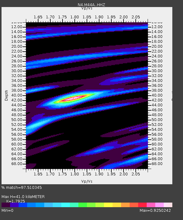
| Estimated Moho Depth: |
41.0 km |
| Estimated Crust Vp/Vs: |
1.79 |
| Assumed Crust Vp: |
6.498 km/s |
| Estimated Crust Vs: |
3.625 km/s |
| Estimated Crust Poisson's Ratio: |
0.27 |
|
| Radial Match: |
97.510345 % |
| Radial Bump: |
250 |
| Transverse Match: |
87.113304 % |
| Transverse Bump: |
400 |
| SOD ConfigId: |
13570011 |
| Insert Time: |
2019-04-28 10:42:54.412 +0000 |
| GWidth: |
2.5 |
| Max Bumps: |
400 |
| Tol: |
0.001 |
|

Signal To Noise
| Channel | StoN | STA | LTA |
| N4:M44A: :HHZ:20170720T22:43:01.690015Z | 44.853363 | 4.576E-6 | 1.0202133E-7 |
| N4:M44A: :HHN:20170720T22:43:01.690015Z | 22.78023 | 1.0655425E-6 | 4.6774883E-8 |
| N4:M44A: :HHE:20170720T22:43:01.690015Z | 19.425053 | 1.1948123E-6 | 6.150883E-8 |
| Arrivals |
| Ps | 5.1 SECOND |
| PpPs | 17 SECOND |
| PsPs/PpSs | 22 SECOND |


