You are here: Home > Network List > N4 - Central and EAstern US Network Stations List
> Station Y45B Coffeeville, MS, USA > Earthquake Result Viewer
Y45B Coffeeville, MS, USA - Earthquake Result Viewer
| Earthquake location: |
Dodecanese Islands, Greece |
| Earthquake latitude/longitude: |
36.9/27.5 |
| Earthquake time(UTC): |
2017/07/20 (201) 22:31:12 GMT |
| Earthquake Depth: |
10 km |
| Earthquake Magnitude: |
6.7 Mww |
| Earthquake Catalog/Contributor: |
NEIC PDE/us |
|
| Network: |
N4 Central and EAstern US Network |
| Station: |
Y45B Coffeeville, MS, USA |
| Lat/Lon: |
33.87 N/89.54 W |
| Elevation: |
101 m |
|
| Distance: |
88.3 deg |
| Az: |
312.124 deg |
| Baz: |
45.569 deg |
| Ray Param: |
0.042675618 |
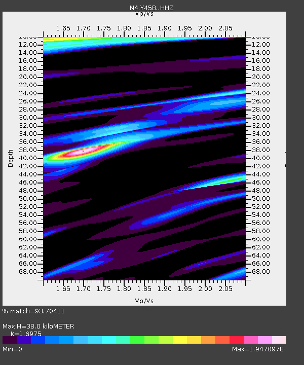
| Estimated Moho Depth: |
38.0 km |
| Estimated Crust Vp/Vs: |
1.70 |
| Assumed Crust Vp: |
6.201 km/s |
| Estimated Crust Vs: |
3.653 km/s |
| Estimated Crust Poisson's Ratio: |
0.23 |
|
| Radial Match: |
93.70411 % |
| Radial Bump: |
364 |
| Transverse Match: |
82.259254 % |
| Transverse Bump: |
400 |
| SOD ConfigId: |
13570011 |
| Insert Time: |
2019-04-28 10:43:50.839 +0000 |
| GWidth: |
2.5 |
| Max Bumps: |
400 |
| Tol: |
0.001 |
|

Signal To Noise
| Channel | StoN | STA | LTA |
| N4:Y45B: :HHZ:20170720T22:43:31.849988Z | 47.444157 | 5.2481187E-6 | 1.1061675E-7 |
| N4:Y45B: :HHN:20170720T22:43:31.849988Z | 5.0528946 | 1.2487948E-6 | 2.471444E-7 |
| N4:Y45B: :HHE:20170720T22:43:31.849988Z | 6.025032 | 8.9075496E-7 | 1.4784236E-7 |
| Arrivals |
| Ps | 4.4 SECOND |
| PpPs | 16 SECOND |
| PsPs/PpSs | 21 SECOND |


