You are here: Home > Network List > N4 - Central and EAstern US Network Stations List
> Station Y60A Bolivia, NC, USA > Earthquake Result Viewer
Y60A Bolivia, NC, USA - Earthquake Result Viewer
| Earthquake location: |
Dodecanese Islands, Greece |
| Earthquake latitude/longitude: |
36.9/27.5 |
| Earthquake time(UTC): |
2017/07/20 (201) 22:31:12 GMT |
| Earthquake Depth: |
10 km |
| Earthquake Magnitude: |
6.7 Mww |
| Earthquake Catalog/Contributor: |
NEIC PDE/us |
|
| Network: |
N4 Central and EAstern US Network |
| Station: |
Y60A Bolivia, NC, USA |
| Lat/Lon: |
34.00 N/78.22 W |
| Elevation: |
7.0 m |
|
| Distance: |
81.2 deg |
| Az: |
305.961 deg |
| Baz: |
51.312 deg |
| Ray Param: |
0.047770217 |
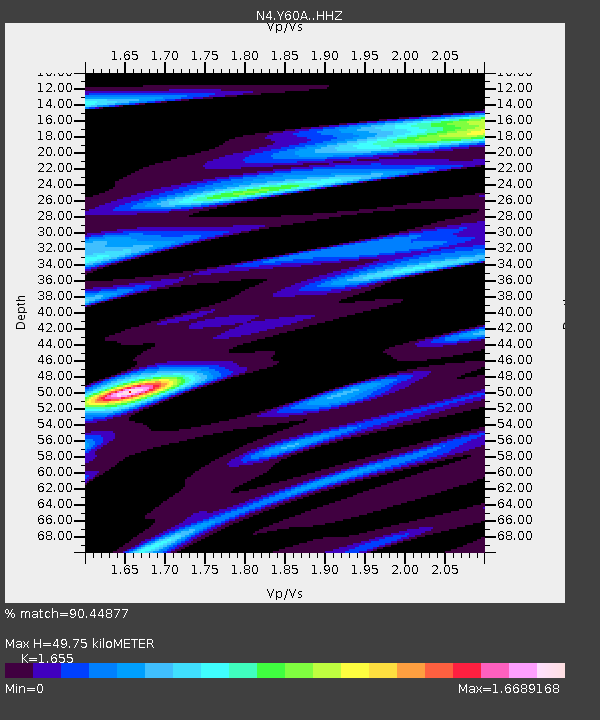
| Estimated Moho Depth: |
49.75 km |
| Estimated Crust Vp/Vs: |
1.65 |
| Assumed Crust Vp: |
6.565 km/s |
| Estimated Crust Vs: |
3.966 km/s |
| Estimated Crust Poisson's Ratio: |
0.21 |
|
| Radial Match: |
90.44877 % |
| Radial Bump: |
400 |
| Transverse Match: |
72.460106 % |
| Transverse Bump: |
400 |
| SOD ConfigId: |
13570011 |
| Insert Time: |
2019-04-28 10:43:53.742 +0000 |
| GWidth: |
2.5 |
| Max Bumps: |
400 |
| Tol: |
0.001 |
|

Signal To Noise
| Channel | StoN | STA | LTA |
| N4:Y60A: :HHZ:20170720T22:42:55.959973Z | 23.369982 | 2.8676457E-6 | 1.2270637E-7 |
| N4:Y60A: :HHN:20170720T22:42:55.959973Z | 4.3896437 | 8.938986E-7 | 2.0363807E-7 |
| N4:Y60A: :HHE:20170720T22:42:55.959973Z | 3.8710842 | 9.1661644E-7 | 2.3678545E-7 |
| Arrivals |
| Ps | 5.1 SECOND |
| PpPs | 20 SECOND |
| PsPs/PpSs | 25 SECOND |


