You are here: Home > Network List > TA - USArray Transportable Network (new EarthScope stations) Stations List
> Station P31A Stockton, KS, USA > Earthquake Result Viewer
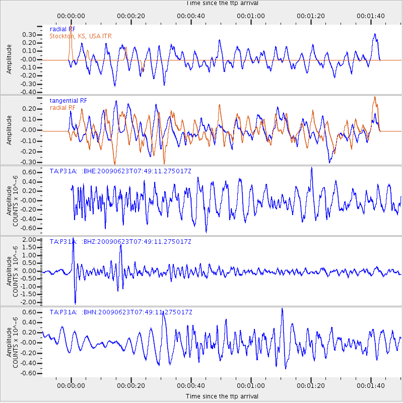
P31A Stockton, KS, USA - Earthquake Result Viewer
*The percent match for this event was below the threshold and hence no stack was calculated.
| Earthquake location: |
Near East Coast Of Honshu, Japan |
| Earthquake latitude/longitude: |
38.8/142.4 |
| Earthquake time(UTC): |
2009/06/23 (174) 07:37:17 GMT |
| Earthquake Depth: |
37 km |
| Earthquake Magnitude: |
5.7 MB, 5.0 MS, 5.6 MW, 5.6 MW |
| Earthquake Catalog/Contributor: |
WHDF/NEIC |
|
| Network: |
TA USArray Transportable Network (new EarthScope stations) |
| Station: |
P31A Stockton, KS, USA |
| Lat/Lon: |
39.52 N/99.38 W |
| Elevation: |
665 m |
|
| Distance: |
83.7 deg |
| Az: |
43.286 deg |
| Baz: |
316.198 deg |
| Ray Param: |
$rayparam |
*The percent match for this event was below the threshold and hence was not used in the summary stack. |
|
| Radial Match: |
57.875973 % |
| Radial Bump: |
400 |
| Transverse Match: |
37.833836 % |
| Transverse Bump: |
400 |
| SOD ConfigId: |
2648 |
| Insert Time: |
2010-03-06 02:08:53.164 +0000 |
| GWidth: |
2.5 |
| Max Bumps: |
400 |
| Tol: |
0.001 |
|
Signal To Noise
| Channel | StoN | STA | LTA |
| TA:P31A: :BHZ:20090623T07:49:11.275017Z | 11.260413 | 8.098104E-7 | 7.191658E-8 |
| TA:P31A: :BHN:20090623T07:49:11.275017Z | 0.78584063 | 1.5373305E-7 | 1.9562879E-7 |
| TA:P31A: :BHE:20090623T07:49:11.275017Z | 0.9666051 | 1.8861573E-7 | 1.9513215E-7 |
| Arrivals |
| Ps | |
| PpPs | |
| PsPs/PpSs | |


