You are here: Home > Network List > GS - US Geological Survey Networks Stations List
> Station KAN11 Stewart Ranch, Harper County, KS, USA > Earthquake Result Viewer
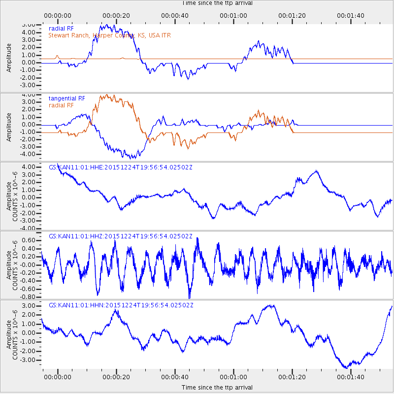
KAN11 Stewart Ranch, Harper County, KS, USA - Earthquake Result Viewer
*The percent match for this event was below the threshold and hence no stack was calculated.
| Earthquake location: |
Southern East Pacific Rise |
| Earthquake latitude/longitude: |
-55.8/-123.1 |
| Earthquake time(UTC): |
2015/12/24 (358) 19:44:03 GMT |
| Earthquake Depth: |
12 km |
| Earthquake Magnitude: |
6.2 MWW, 6.1 MWB, 6.2 MWC |
| Earthquake Catalog/Contributor: |
NEIC PDE/NEIC COMCAT |
|
| Network: |
GS US Geological Survey Networks |
| Station: |
KAN11 Stewart Ranch, Harper County, KS, USA |
| Lat/Lon: |
37.21 N/97.91 W |
| Elevation: |
410 m |
|
| Distance: |
95.1 deg |
| Az: |
19.957 deg |
| Baz: |
193.985 deg |
| Ray Param: |
$rayparam |
*The percent match for this event was below the threshold and hence was not used in the summary stack. |
|
| Radial Match: |
44.701496 % |
| Radial Bump: |
400 |
| Transverse Match: |
32.112423 % |
| Transverse Bump: |
400 |
| SOD ConfigId: |
1399611 |
| Insert Time: |
2016-01-28 00:27:17.979 +0000 |
| GWidth: |
2.5 |
| Max Bumps: |
400 |
| Tol: |
0.001 |
|
Signal To Noise
| Channel | StoN | STA | LTA |
| GS:KAN11:01:HHZ:20151224T19:56:54.02502Z | 1.2658767 | 2.2732863E-7 | 1.7958197E-7 |
| GS:KAN11:01:HHN:20151224T19:56:54.02502Z | 0.6298597 | 1.5431688E-6 | 2.4500198E-6 |
| GS:KAN11:01:HHE:20151224T19:56:54.02502Z | 0.5256582 | 8.001969E-7 | 1.5222761E-6 |
| Arrivals |
| Ps | |
| PpPs | |
| PsPs/PpSs | |


