You are here: Home > Network List > OK - Oklahoma Seismic Network Stations List
> Station CHOK Chandler, Oklahoma, USA > Earthquake Result Viewer
CHOK Chandler, Oklahoma, USA - Earthquake Result Viewer
| Earthquake location: |
Dodecanese Islands, Greece |
| Earthquake latitude/longitude: |
36.9/27.5 |
| Earthquake time(UTC): |
2017/07/20 (201) 22:31:12 GMT |
| Earthquake Depth: |
10 km |
| Earthquake Magnitude: |
6.7 Mww |
| Earthquake Catalog/Contributor: |
NEIC PDE/us |
|
| Network: |
OK Oklahoma Seismic Network |
| Station: |
CHOK Chandler, Oklahoma, USA |
| Lat/Lon: |
35.56 N/97.06 W |
| Elevation: |
338 m |
|
| Distance: |
91.4 deg |
| Az: |
317.78 deg |
| Baz: |
41.319 deg |
| Ray Param: |
0.041608132 |
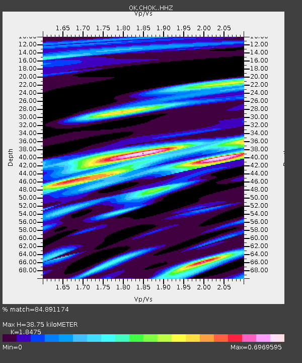
| Estimated Moho Depth: |
38.75 km |
| Estimated Crust Vp/Vs: |
1.85 |
| Assumed Crust Vp: |
6.426 km/s |
| Estimated Crust Vs: |
3.478 km/s |
| Estimated Crust Poisson's Ratio: |
0.29 |
|
| Radial Match: |
84.891174 % |
| Radial Bump: |
400 |
| Transverse Match: |
72.61975 % |
| Transverse Bump: |
400 |
| SOD ConfigId: |
13570011 |
| Insert Time: |
2019-04-28 10:44:35.163 +0000 |
| GWidth: |
2.5 |
| Max Bumps: |
400 |
| Tol: |
0.001 |
|

Signal To Noise
| Channel | StoN | STA | LTA |
| OK:CHOK: :HHZ:20170720T22:43:45.989026Z | 16.086994 | 1.9687259E-6 | 1.2237997E-7 |
| OK:CHOK: :HHN:20170720T22:43:45.989026Z | 2.2513933 | 4.6035368E-7 | 2.0447501E-7 |
| OK:CHOK: :HHE:20170720T22:43:45.989026Z | 1.9685704 | 5.783819E-7 | 2.9380806E-7 |
| Arrivals |
| Ps | 5.2 SECOND |
| PpPs | 17 SECOND |
| PsPs/PpSs | 22 SECOND |


